Kyiv Metro
As one of the members of his cabinet argued: [...] [The engineers] have an idea to construct trams, but not the ones [that ride] now, - those overground, and [those] in tunnels that are called "metropoliten" [underground].
The meeting minutes stated that "the author successfully resolved one of the problems of reconstruction of the city of Kyiv and establishment of intra-city transportation and also answered various practical questions about the Metro plan (the routes of the underground, the position of stations)."
A few days before, on July 5, the Kyiv newspaper Bil'shovyk published an article that featured a project of underground, prepared by engineers from the Transport Devices Institute in Ukraine's Soviet Socialist Republic's Academy of Sciences.
The resolution planned for underground construction, thus the government ordered the appropriate organizations to continue preparatory works, create a technical project, and estimate total costs.
The competition commission wanted all seven stations to have a Stalinist style: richly decorated and adorned with Communist symbols and national (Ukrainian) motifs.
A commission analyzing the works was created, consisting of activists, engineering and architecture experts from both the Ukrainian SSR and the USSR, sculptors, artists, writers, and the heads of the organizations Glavtunelstroy, Metrogiprotrans, and Kyivmetrobud.
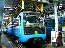
[9] On 22 October 1960, a test run was made by Alexey Semagin, a motorman of the Moscow Metro, and Ivan Vynogradov, the former train operator from the central railway station of Kyiv-Pasazhyrskyi.
In 1978, Pionerska station was opened, which might have been the next step towards the realization of Stalin times projects (the line was planned to be extended to Brovary, the satellite town of Kyiv).
Construction then started to the southwest of the newly opened terminus but was soon interrupted by an accident while workers were drilling through the difficult terrain under the Lybid river.
The older tunnels, over 300 m (980 ft) each, partially cut by the ceiling of the Zoloti Vorota station, still exist and are now accessible only for maintenance by staff.
The initial 2.1 km (1.3 mi) segment was finished on 31 December 1989 and featured three stations: Zoloti Vorota, Palats Sportu, and Mechnikova (now Klovska).
Initially, this bridge (which was open from the sides) was intended to be covered by an aluminium construction, but this was found to be ineffective protection against snow and rain.
Difficult terrain made the work fall behind the schedule, partly due to accidents (such as one in January 2006 during the construction of the Demiivska station[45]).
[53] 8 December 2023, years after the controversial construction was finished, Kyiv City Council informed that the tunnel of the second line between Lybidska and Demiivska stations has been depressurized and the rails are flooded.
[59] On 18 December, the administration of Kyiv Metro announced that the repair works between Tarasa Shevchenka and Pochaina stations will start in the summer of 2024 but they won't need the train movement to be stopped.
[61] On 24 January 2024, Kyiv Department of Transport Infrastructure announced that by the results of the expertise the cause of the accident was a bad quality of the project and construction work.
Finally, in July 2008, the trains were accepted by the governmental commission and were given a special license allowing them to be mass-produced (following Ukrainian technical standards).
All of its stations on the eastern bank of the Dnieper river are either at or above ground level, this is attributed to a similar experiment to Moscow's Filyovskaya Line.
The five original stations on this line managed to survive Nikita Khrushchev's struggle with decorative "extras"[clarification needed], although more pompous projects were proposed in Stalin's time.
It starts on the western side of the Dnieper river before crossing it on a partially covered bridge and then going on to the southeastern residential districts of Kyiv.
[79] The Kyiv Metro follows a standard Soviet design: a triangular layout of three lines that intersect in the city center, making six radii, and stations that are built very deep underground and could potentially double as bomb shelters.
The original stations from the first stage of construction are elaborately decorated, showing the postwar Stalinist architecture blended with traditional Ukrainian motifs.
Many first projects for stations offered at the beginning of the 1950s were full of rich decorative elements such as mosaics, ornaments, bas-reliefs, sculptures, and marble.
Of these, 276 would replace older trains whose operation terms have expired, 62 would be added to the Syretsko-Pecherska line to ensure regular scheduling, and 371 would be introduced across newer sections of the metro system.
The line will continue westwards along the northern slope of the Starokyivska Hora and into the northwestern part of central Kyiv, where it will turn south and reach the Kyiv-Pasazhyrskyi Railway Station.
In the 2005 general plan, the line was supposed to turn sharply from Chevonyi Khutir to Darnytsia railway station, with a subsequent extension to Livoberezhna.
Examples of this include the station names Ploshcha Zhovtnevoi Revolutsii, Zhovtneva, and Chervonoarmiyska[citation needed] (later renamed to Maidan Nezalezhnosti, Beresteiska, and Palats Ukraina, respectively) which when translated into Russian would become Oktyabrskaya and Krasnoarmeiskaya.
In the early to mid-1980s, due in part to both Volodymyr Shcherbytsky's gradual Russification campaign and Kyiv becoming increasingly Russophonic, the metro started to change as well.
After the fall of the Soviet Union in late 1991, both signs and voice announcements were changed from bilingual to just Ukrainian as the official language of the state.
In 2018, "Petrivka" (named after the Soviet politician Grigory Petrovsky) was re-designated as "Pochaina" after the river that once flowed nearby,[151] to comply with 2015 decommunization laws.