La Mauricie National Park
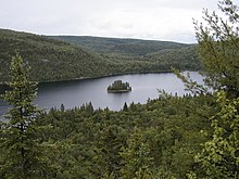
It covers 536 km2 (207 sq mi) in the southern Canadian Shield region bordering the Saint Lawrence lowlands.
The name "Mauricie" was first used in 1933 by Bishop Albert Tessier to designate an administrative region of Government of Québec, for which the Valley of Saint-Maurice is the main feature.
[3] The watershed of Saint-Maurice River is also administered in part by the administrative regions of Lanaudière (West), James Bay (North) and Saguenay-Lac-Saint-Jean (East).
Moreover, the administrative region of Mauricie covers other watersheds including the Champlain River and half the territory of the Batiscanie, Quebec.
The Mauricie National Park is located in the green area Level I established by Commission for Environmental Cooperation of Northern Forests.
The park is part of habitat ranges from maple to yellow birch (Acer saccharum and Betula papyrifera), which occupies the illuminated slopes and well-drained soils.
[12] Mixed forests are occupied by the ruffed grouse (Bonasa umbellus), the blue jay (Cyanocitta cristata), the black-capped chickadee (Poecile atricapillus) and the purple finch (Carpodacus purpureus).
[12] The park includes eight species at risk, the whip-poor-will (Caprimulgus vociferus), the nighthawk (Chordeiles minor), the chimney swift (Chaetura pelagica), the olive-sided flycatcher (Contopus cooperi), the Canada warbler (Wilsonia canadensis), the peregrine falcon (Falco peregrinus) and the rusty blackbird (Euphagus carolinus).
[11] Mammals that inhabit this park include snowshoe hare (Lepus americanus), raccoon (Procyon lotor), moose (Alces alces americana), beaver (Castor canadensis), porcupine (Erethizon dorsatum), groundhog (Marmota monax), river otter (Lontra canadensis), marten (Martes americana), red fox (Vulpes vulpes), black bear (Ursus americanus), coyote (Canis latrans), lynx (Lynx canadensis), mink (Neogale vison), fisher (Pekania pennanti), and eastern wolf (Canis lycaon).
This population was threatened by the introduction at the beginning of the century of several invasive fish species, such as chub (Semotilus atromaculatus).
[17] The 34 "protohistoric" archeological sites suggest that Native Americans who frequented the park lived in small family groups.
[17] Until the 17th century, the Attikamekw and Algonquian peoples respectively occupied the northern and southern basins of the Saint-Maurice River, making a living mainly by trap and hunting.
[18] At the end of the 19th century, rich American tourists settled in the area and opened private hunting and fishing clubs.
Although they allowed a certain amount of nature protection in the territory of the park, these clubs introduced many exotic fish species into the lakes.
[19] A cottage at "lac des cinq" (Lake of the Five), once owned by the Brown family, is today used by the park staff.
[19] The park offers a canoe camping circuit allowing access to a dozen lakes in the hinterland connected by many portages.