La Paz
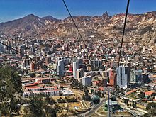
The city, in west-central Bolivia 68 km (42 mi) southeast of Lake Titicaca, is set in a canyon created by the Choqueyapu River.
At an elevation of roughly 3,650 m (11,975 ft) above sea level, La Paz is the highest capital city in the world.
[6][7] Due to its altitude, La Paz has an unusual subtropical highland climate, with rainy summers and dry winters.
La Paz was founded on 20 October 1548, by the Spanish conquistador Captain Alonso de Mendoza, at the site of the Inca settlement of Laja as a connecting point between the commercial routes that led from Potosí and Oruro to Lima; the full name of the city was originally Nuestra Señora de La Paz (meaning Our Lady of Peace) in commemoration of the restoration of peace following the insurrection of Gonzalo Pizarro and fellow conquistadors against the first viceroy of Peru.
In 1781, the indigenous leader and independence activist Túpac Katari laid siege to the city for a total of six months, but was finally defeated.
La Paz is an important political, administrative, economic, and sports center of Bolivia; it generates 24% of the nation's gross domestic product and serves as the headquarters for numerous Bolivian companies and industries.
[11] La Paz is also an important cultural center of South America, as it hosts several landmarks dating from colonial times, such as the San Francisco Church, the Metropolitan Cathedral, the Plaza Murillo and Jaén Street.
[14] The Spanish conquistadors founded the city in 1548 with the name Nuestra Señora de La Paz (meaning Our Lady of Peace).
The name commemorated the restoration of peace following the insurrection of Gonzalo Pizarro and fellow conquistadors four years earlier against Blasco Núñez Vela, the first viceroy of Peru.
[citation needed] Spain controlled La Paz with a firm grip and the Spanish king had the last word in all matters political, but consultation was extended, taking months or longer by sea.
[citation needed] In 1781, for a total of six months, a group of Aymara people laid siege to La Paz.
[citation needed] On 16 July 1809, Pedro Domingo Murillo said that the Bolivian revolution was igniting a lamp that nobody would be able to turn off.
[citation needed] This event is known as the Primer Grito Libertario de América and brought about the Bolivian War of Independence.
In 1898, La Paz was made the de facto seat of the national government, with Sucre remaining the nominal historical as well as judiciary capital.
They were not allowed to enter certain public places and were banned from cinemas and some restaurants, with more emphasis in Bolivian eastern cities like Santa Cruz De La Sierra.
The metropolitan area is near to the Cordillera Real range, which includes such notable mountains as Illimani (guardian of La Paz), Mururata, Huayna Potosi, Chacaltaya, Kunturiri, Llamp'u, Chachakumani, Chearoco, and Ancohuma.
The city's main thoroughfare, which roughly follows the river, changes names over its length, but the central tree-lined section running through the downtown core is called the Prado.
The satellite city of El Alto, where the airport is, is spread over a broad area to the west of the canyon, on the Altiplano.
Temperatures in central La Paz, at 3,600 meters (11,811 feet), and in the Zona Sur (Southern Zone), at 3,250 m (10,663 ft) above sea level are warmer and are classified as subtropical highland climates (Köppen: Cwb).
In the highest part of the city, above 4,000 meters, the two cloudiest months are February and March, in late summer, when sunshine averages around 5 hours per day.
[25] The city of La Paz has a consistently decreasing volume of colonial buildings, mostly centered around the vicinity of the Plaza Murillo.
Due to a lack of funds and the inability of property owners to pay for restorations to colonial buildings, many have been torn down, or are in a dilapidated state.
Although there has been an increasing number of projects and propositions to restore some of the city's colonial buildings, the future of these historic edifices remains uncertain.
Due to the long period of high inflation and economic struggle faced by Bolivians in the 1980s and early 1990s, a large informal economy developed.
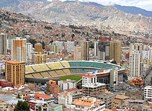
Always Ready frequently play at the Estadio Rafael Mendoza which belongs to The Strongest, who rarely use the stadium due to its relatively small capacity.
The home of the Bolivian government is located on Murillo Square and is known as "Palacio Quemado" (Burnt Palace) as it has been on fire several times.
Popular food from La Paz includes: Automobiles and public transportation are the main means to get into the city.
Roads to the west go to Copacabana and Tiwanaku, near Lake Titicaca, and continue to Cuzco, Peru via the border town of Desaguadero.
Departures to smaller cities and towns within the department use informal stations located in Villa Fátima (departures to Los Yungas, Beni and Pando), Upper San Pedro (for Apolo) and near the General Cemetery (for Copacabana, Lake Titicaca, or via Tiwanaku to Desaguadero on the Peruvian border).
These channels divert water that flows from the Zongo Glacier on the slopes of Huayna Potosi and from Condoriri North of El Alto.