La Ronge
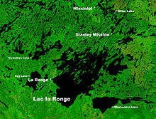
The town is located approximately 250 km (160 mi) north of Prince Albert and lies on the western shore of Lac la Ronge, is adjacent to Lac La Ronge Provincial Park, and is on the edge of the Canadian Shield.
The French verb ronger translates as “to gnaw”, with at least one explanation theorising that 17th- and 18th-century French fur traders referred to the lake as la ronge (literally, the chewed) due to the abundant beaver population along the lake’s shoreline.
Undoubtedly, many of the trees along the water’s edge would have been visibly chewed, or completely gnawed to the ground and taken away by the rodents for their dam construction.
[2] With the extension of Highway 2 from Prince Albert in 1947, La Ronge became a major tourist fishing area.
In the early 1950s and 1960s, the mineral resources in the La Ronge area began to be explored and developed.
The wildfire burned multiple houses before conditions pushed the fire away from the town and crews were able to extinguish it.
Once again in July 2015, La Ronge was threatened by dangerous forest fires that combined forcing approximately 7,000 people to evacuate from their homes.
In total there were over a hundred fires burning in Northern Saskatchewan at once which forced over 13,000 residents to flee their homes, resulting in the province's largest evacuation ever.
With access to all other points north, east and west, and transportation linkage to the south, La Ronge is also the northern hub for the Saskatchewan provincial government.
Several mining companies, government agencies, and airlines now keep offices in La Ronge, and the local Chamber of Commerce has many other retail and service businesses amongst its members.