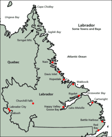
Labrador
The indigenous peoples of Labrador include the Northern Inuit of Nunatsiavut, the Southern Métis of NunatuKavut, and the Innu of Nitassinan.
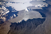
Labrador has a roughly triangular shape that encompasses the easternmost section of the Canadian Shield, a sweeping geographical region of thin soil and abundant mineral resources.
From Cape Chidley to Hamilton Inlet, the long, thin, northern tip of Labrador holds the Torngat Mountains, named after an Inuit spirit believed to inhabit them.
[7][8][9][10][11] The North Coast is the most isolated region of Labrador, with snowmobiles, boats, and planes being the only modern modes of transportation.
Once a refuelling point for plane convoys to Europe during World War II, CFB Goose Bay is now operated as a NATO tactical flight training site.
[22] The highlands above the Churchill Falls were once an ancient hunting ground for the Innu First Nations and settled trappers of Labrador.
After the construction of the hydroelectric dam at Churchill Falls in 1970, the Smallwood Reservoir has flooded much of the old hunting land—submerging several grave sites and trapping cabins in the process.
MV Kamutik, a passenger ferry between the mainland and St. Barbe on the island of Newfoundland, is based in Blanc Sablon, Quebec, near the Labrador border.
Summers are typically cool to mild across Labrador and very rainy, and usually last from late June to the end of August.
Labrador is a very cloudy place, with sunshine levels staying relatively low during spring and summer due to the amount of rain and clouds, before sharply dropping off during September as winter draws nearer.
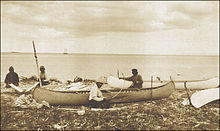
[29] Early settlement in Labrador was tied to the sea as demonstrated by the Innu (formerly called Montagnais) and Inuit, although these peoples also made significant forays throughout the interior.
The area was known as Markland in Greenlandic Norse and its inhabitants were known as the Skrælings.In 1499 and 1500, the Portuguese explorers João Fernandes Lavrador and Pero de Barcelos reached what was probably now Labrador, which is believed to be the origin of its name.
[30] Maggiolo's World Map, 1511, shows a solid Eurasian continent running from Scandinavia around the North Pole, including Asia's arctic coast, to Newfoundland-Labrador and Greenland.
In the 1532 Wolfenbüttel map, believed to be the work of Diogo Ribeiro, along the coast of Greenland, the following legend was added: As he who first sighted it was a farmer from the Azores Islands, this name remains attached to that country.
However, in 1809, the British Imperial government detached Labrador from Lower Canada for transfer to the separate, self-governing Newfoundland Colony.
In October 1943, a German U-boat crew installed an automated weather station on the northern tip of Labrador near Cape Chidley, code-named Weather Station Kurt; the installation of the equipment was the only-known armed German military operation on the North American mainland during the war.
The station broadcast weather observations to the German navy for only a few days, but was not discovered until 1977 when a historian, working with the Canadian Coast Guard, identified its location and mounted an expedition to recover it.
[33] The Canadian government built a major air force base at Goose Bay, at the head of Lake Melville during the Second World War, a site selected because of its topography, access to the sea, defensible location, and minimal fog.
During the first half of the 20th century, some of the largest iron ore deposits in the world were discovered in the western part of Labrador and adjacent areas of Quebec.
Deposits at Mont Wright, Schefferville, Labrador City, and Wabush drove industrial development and human settlement in the area during the second half of the 20th century.
The present community of Labrador West is entirely a result of the iron ore mining activities in the region.
[34] Construction of a large hydroelectric dam project at Muskrat Falls began in 2012 by Nalcor Energy and the Province of Newfoundland.
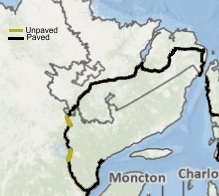
A transmission line began construction in October 2014 and was completed in 2016 that delivers power down to the southern tip of Labrador and underwater across the Strait of Belle Isle to the Province of Newfoundland in 2018.
A southern extension of this highway has opened in stages during the early 2000s and is resulting in significant changes to the coastal ferry system in the Strait of Belle Isle and southeastern Labrador.
[45] Conceivably, if built with federal aid, the 1949 terms of union would be amended to remove ferry service from Nova Scotia to Port aux Basques across the Cabot Strait.
As Canada and Newfoundland were separate Dominions, but both within the British Empire, the matter was referred to the Judicial Committee of the Privy Council[53] (in London).
[54] In 2001, Parti Québécois cabinet ministers Jacques Brassard and Joseph Facal erroneously reasserted that Quebec has never recognized the 1927 border: Les ministres rappellent qu'aucun gouvernement québécois n'a reconnu formellement le tracé de la frontière entre le Québec et Terre-Neuve dans la péninsule du Labrador selon l'avis rendu par le comité judiciaire du Conseil privé de Londres en 1927.
]A Royal Commission in 2002 determined that there is some public pressure from Labradorians to break from Newfoundland and become a separate province or territory.
[61] On January 22, 2005, the Inuit of Nunatsiavut signed the Labrador Inuit Lands Claims Agreement[15] with the federal and provincial governments covering 72,520 km2 (28,000 sq mi) of land,[60] including the entire northern salient of Labrador north of Nain as well as a portion of the Atlantic coast south of there.
[62] In 2010, the Labrador Metis Association changed its name to reflect their newly discovered heritage, and became the NunatuKavut Community Council.