Lahr
When the new body of Municipal Law for Baden-Württemberg came into effect on April 1, 1956, the city was therefore immediately accorded Große Kreisstadt status.
Lahr is located on the western edge of the Black Forest where the Schutter Valley merges with the Upper Rhine River Plains from the east.
The Schutter enters the city from the southeast and runs in a northwesterly direction first through the boroughs of Reichenbach and Kuhbach, then through Lahr (proper) where the Altstadt (historic town centre) is situated on the right bank of the river.
During the last major district reform in Baden-Württemberg in the 1970s Hugsweier, Kippenheimweiler, Kuhbach, Langenwinkel, Mietersheim, Reichenbach and Sulz joined Lahr as new boroughs.
Several of the boroughs include additional, geographically distinct settlements or neighbourhoods that either have a long history of their own or were created as new developments but with areal boundaries that have not been officially defined.
Lahr developed around the Storchenturm ("stork tower") owned by the House of Geroldseck around 1220 and received a city charter around 1278.
The significant tax privileges enjoyed by Lahr allowed the city to quickly grow into a centre of trade during the eighteenth century.
Their successor was the House of Moers-Saarwerden, which gave half the land to Baden as collateral for loans and in 1497 legal ownership was transferred to it.
The suits were decided in favor of the citizens of Lahr and thwarted Nassau's attempt at absolute rule.
In 1803 Lahr and the surrounding land in Baden became the seat of a court, whose areal boundaries were modified several times.
After World War II, Lahr became one of the bases for the French until France left the North Atlantic Treaty Organization in 1966.
Following the closing down of the "old" Brigade Area in North Rhine-Westphalia centred around Iserlohn, Hemer, Deilinghofen as well as Werl and Soest (1970–1971)the Land Forces and their families were transferred to the Lahr area to join the existing Air Force contingent.
Hugsweier, Burgheim, Dinglingen, Langenwinkel, Mietersheim and Sulz used to be ruled by the same rulers as Lahr itself and therefore shared a great deal of the city's history.
It was built starting in 1787 in the area of the Nassau forest, which was cut down to make room for the new village, on land that belonged to Dinglingen.
In 1965 the German Ministry of Defense decided therefore to move the village and Langenwinkel was recreated between 1968 and 1971 several kilometres southeast of the Hurster Hof.
During the fourteenth century the part owned by the Tiersbergs came after several detours into the possession of Baden and was given to the Röder vassals as a fief.
Additional Catholic parishes exist in Dinglingen (Holy Spirit with church St. Martin in Hugsweier), Kuhbach (Mary Ascension and Chapel of Our Dear Lady), Reichenbach and Sulz (St. Peter and Paul).
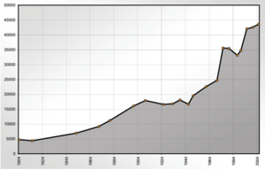
In conjunction with several district reforms the following towns were merged with Lahr: Figures reflect city limits at the time and are estimates (until 1870), Census data (¹), or official extensions thereof, counting only primary residences.
¹ Census data Approximately 9,000 of Lahr's citizens are descendants of Germans who settled in Russia, and another 4,000 are descendants of other Soviet nationalities and so every fourth citizen of Lahr currently (as of 2006) lists the former Soviet Union as his or her place of birth.
In addition, there was an executor and a regal advocate to facilitate matters between the city and the ruling houses.
Other notables are the City park with museum in the Jamm villa and the foundry in the borough of Reichenbach.
The new city hall, which was originally constructed as the home for an entrepreneur, features a facade by Friedrich Weinbrenner.
It is visited by thousands from all over Germany and neighboring countries and features a tremendously decorated Altstadt (historic center of town).
Lahr (Schwarzw) station is a stop on the Rhine Valley Railway of the Deutsche Bahn but the former main train station in the heart of town and the tracks of the local railway from Seelbach (Schutter) to Kehl have been completely removed.
The Offenburger Tageblatt also publishes a daily edition with a very comprehensive local section for Lahr and the surrounding area.
Division of the Bereitschaftspolizei and several regional and state courts and of the Departments of Finance and Labor, as well as a notary public maintain branch locations here.