Lake Burley Griffin
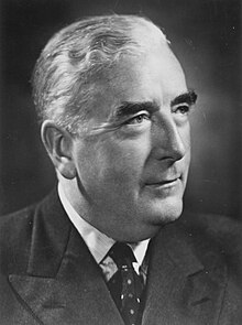
After political disputes and consideration of other proposed variations, excavation work began in 1960 with the energetic backing of Australian Prime Minister Robert Menzies.
[3] The Molonglo River flowed through the site, which was a flood plain[5] and Scrivener's survey showed in grey an area clearly representing an artificial lake—similar to the lake later created—and four possible locations for a dam to create it.
[3] The American architect Walter Burley Griffin won the contest and was invited to Australia to oversee the construction of the nation's new capital after the judges' decision was ratified by King O'Malley, the Minister for Home Affairs.
[4][8] Griffin's proposal, which had an abundance of geometric patterns, incorporated concentric hexagonal and octagonal streets emanating from several radii.
[3][12] The lakes stretched from east to west and divided the city in two; a land axis perpendicular to the central basin stretched from Capital Hill—the future location of the new Parliament House on a mound on the southern side—north northeast across the central basin to the northern banks along Anzac Parade to the Australian War Memorial (although a casino was originally planned in its place).
[12] The straight edge of the circular segment that formed the central basin was designated the water axis, and it extended northwest towards Black Mountain.
[13] A rubbish dump stood on the northern banks of the location of the central basin,[28] and no earth had been moved since Griffin's departure three decades earlier.
[30] In 1953, the NCPDC excised the West Lake from its plans and replaced it with a winding stream,[31] which was 110 metres (360 ft) wide and covered around a fifth of the original area.
[32] As the NCPDC had only advisory powers, this change was attributed to the influence of senior officials in the Department of the Interior who felt that Griffin's plan was too grandiose.
[32] However, according to engineering reports that were ignored, the smaller plan would actually cost more money and require a more complicated structure of dams that would in any case be less able to prevent flooding.
[38] Critics bitterly insinuated that politically influential members of the Royal Canberra Golf Club, whose course was situated on the location of the proposed West Lake, were responsible for the change in policy.
[44] A powerful Senate Select Committee oversaw the NCDC and renowned British architect Sir William Holford was brought in to fine-tune Griffin's original plans.
[47] However, while Menzies was on holiday, some officials from the Department of Treasury convinced ministers to withhold money needed for the lake, so the start of the construction was delayed.
[52][60][61] Care was taken to excavate the entire lake floor to a depth of at least 2 metres (6.6 ft) to provide sufficient clearance for boat keels.
Prime Minister Menzies unlocked a ceremonial chain before the motorcade and pageant crossed the lake in front of a large crowd.
[47] The dam was designed and built by Rheinstahl Union Bruckenbau in West Germany,[60][64] and used state-of-the-art post-tensioning techniques to cope with any problems or movements in the riverbed.
The valves on the Scrivener Dam were closed on 20 September 1963 by Minister for the Interior, Gordon Freeth; Menzies was absent due to ill health.
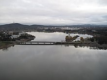
[49] On 17 October 1964, Menzies (by now Sir Robert) commemorated the filling of the lake and the completion of stage one with an opening ceremony amid the backdrop of sailing craft.
[53] The completion of the central basin placed a waterway between Parliament House and the War Memorial and a landscaped boulevard was built along the land axis.
[14][52] This occurred after the public were encouraged to watch the controlled demolition of the hospital in 1997, but a girl was killed by flying debris, leading to criticism of the ACT Government.
[85] At the start of the 21st century, the layout of the lake was significantly altered for the first time since its construction, through the Kingston Foreshores Redevelopment on southern shore of the East Basin, which was planned in 1997.
[86] A bidding process was enacted,[87] multimillion-dollar luxury apartment complexes were built in the suburb of Kingston,[88] driving property values to record-breaking levels.
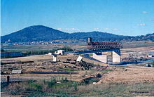
[86] The Kingston Powerhouse, which used to provide the city's power supply, was converted into the Canberra Glassworks in 2007, 50 years after the electricity generators stopped.
Public parks exist along most of the shore line, with free electric barbecue facilities, fenced-in swimming areas, picnic tables and toilets.
[14] Commonwealth Park is the location of Floriade, an annual flower festival that is held for around a month in spring and attracts upwards of 300,000 visitors,[104] a number comparable to the city population.
[119] The East and Central Basins, closer to populated areas, are zoned for secondary contact water sports such as sailing or rowing.
[121] Blue-green algae (more correctly cyanobacteria) produce toxins, which can be harmful for humans and any other animals that come in contact with the contaminated water.
The problem has eased with the construction of the Googong Dam, and the spectre of heavy metal pollution has receded,[120] partly due to the closure of some lead mines upstream.
One of the motives for raising the level of Murray cod and golden perch is to balance the ecosystem by having them act as native predators of other fish.
According to a government report, the reason for the low survival rate is unknown, but the dominance of carp in the competition for food is one suggested theory.