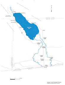
Lake Cahuilla
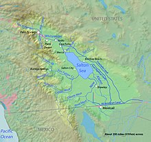
Located in the Coachella and Imperial valleys, it covered surface areas of 5,700 km2 (2,200 sq mi) to a height of 12 m (39 ft) above sea level during the Holocene.
This tectonic depression forms the northern basin of the Gulf of California, but it was separated from the sea proper by the growth of the Colorado River Delta.
These resources supported human populations on its shores, as evidenced by a number of archeological sites and mythological references to the lake in the traditions of the Cahuilla.
[20] Towns in areas formerly covered by Lake Cahuilla include, from north to south, Indio, Thermal, Mecca, Mortmar, Niland, Calipatria, Brawley, Imperial and El Centro.
[37] Sedimentation of the Colorado River Delta directed water into the Lake Cahuilla area,[25] a process that was more likely to happen during humid periods.
[20] Presently the only major streams entering the basin come from mountains to the west and northwest, as well as the New and Alamo Rivers, but during the Pleistocene they likely transported more water.
[4] When lower sea levels entrenched a more southerly course of the Colorado River, Lake Cahuilla may have been nourished solely by local runoff during the Wisconsin glaciation.
[49] Shorelines lie at altitudes of 7.6–18.3 metres (25–60 ft) above sea level; the variation is probably caused by slumping, measurement problems, and different wave cut and beach deposit thicknesses.
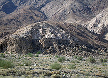
[24] The nature of the shoreline varies; to the east it includes 7.6 metres (25 ft) high wavecut cliffs beneath the Mecca Hills over baymouth bars farther south, one of which reaches a length of 5.6 kilometres (3.5 mi) at the Orocopia Mountains.
[24] Only about half of the discharge of the Colorado River was needed to sustain Lake Cahuilla; the rest drained across the delta into the Gulf of California.
[26] A 12 metres (39 ft) above sea level the outflow sill close to Cerro Prieto formed the likely spillway for the lake.
The present day sill is about 2 kilometres (1.2 mi) long,[64] and Cerro Prieto lies on the drainage divide between the New River and Rio Hardy watersheds.
Drainage changes in the Colorado River Delta probably account for most of the water budget increases responsible for the formation of Lake Cahuilla.
[76] A colder climate introduced cold-limited animal species which appeared at lower altitudes, and glaciers formed on the San Bernardino Mountains.
[78] Sediments of Lake Cahuilla have shown deformation structures[87] similar to these formed by the 1971 San Fernando earthquake in the Van Norman Reservoir of the Los Angeles Aqueduct.
[86] Cerro Prieto appears to be 108,000 ± 46,000 years old based on potassium-argon dating,[113] but legends of native Cucupah people may indicate Holocene activity.
[123] The shores of Lake Cahuilla developed arrowweed, tules and willowweed, with mesquite at distance to the shoreline[124] and microbial mats underwater.
[125] Land plants identified in Lake Cahuilla sediments include evening primroses, pine, Polypodiaceae, ragweed, saltbushes, Selaginella sinuites and sunflower.
[116] During periods when the level in the lake rose, vegetation in the flooded areas drowned and the organic material coming from it was washed ashore and later buried in coastal sediments.
[133] The flora and fauna along the seashores was probably robust enough to tolerate lake level drops for a while before increased salinity resulted in their disappearance.
[137] It was assumed at first that the lake existed in a single long interval between 1000 and 1500; however, later a succession of wet and dry phases was determined from radiocarbon dating.
[148] Based on observations made by Juan Bautista de Anza during his 1774 trip through the region, Lake Cahuilla did not exist by that point.
[50] Originally it was believed that Lake Cahuilla formed around 900 AD and existed until 1500 but with fluctuations as the Colorado River changed its course.
[165] At first the Whitewater River and local washes were considered the primary source of these sands,[166] which would have been transported to the Algodones area by longshore drift.
[85] Minerals identified include biotite, chlorite, illite, kaolinite, montmorillonite and muscovite, with varying colors depending on the origin of the sediments.
[169][170] These lacustrine materials bury the northern part of the Colorado River Delta,[171] and they give the ground a grayish color.
[179] Patayan pottery and stone artifacts are among the archeological finds made at the Lake Cahuilla highstand shoreline,[180] along with petroglyphs in the travertine.
[183] The Elmore Site, discovered in 1990 during an archeological survey that accompanied work to improve State Route 86,[185] lies close to the southwestern coast of Lake Cahuilla, about 67 metres (220 ft) beneath the highstand level.
Indeed, evidence indicates that at least three different ethnic groups – Cahuilla, Kumeyaay and Cucapa – existed around the later history of the lake in its area.
The effects of the lake's expansion most likely were dominantly positive on the communities concerned, unlike in the Colorado River Delta which lost part of its water supply.