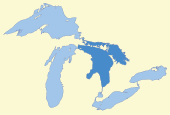
Lake Huron
Lake Huron has a fairly large drainage basin covering parts of Michigan and Ontario.
[14] When measured at the low water datum, the lake contains a volume of 850 cubic miles (3,500 km3) and a shoreline length (including islands) of 3,827 mi (6,159 km).
In the winter of 1964, Lakes Michigan and Huron reached their lowest level at 1.38 feet (42 cm) below datum.
The water then flows south to the St. Clair River, at Port Huron, Michigan and Sarnia, Ontario.
[19] That a trade network brought obsidian from Oregon almost ten thousand years ago to be used for toolmaking was confirmed by a 2013 underwater discovery along the ridge.
[20] On the eve of European contact, the extent of development among Eastern Woodlands Native American societies is indicated by the archaeological evidence of a town on or near Lake Huron that contained more than one hundred large structures housing a total population of between 4,000 and 6,000.
[21] The French, the first European visitors to the region, often referred to Lake Huron as La Mer Douce, "the fresh-water sea".
[24] On October 26, 2010,[25] the Karegnondi Water Authority was formed to build and manage a pipeline from the lake to Flint, Michigan.
Passing the Straits of Mackinac, La Salle made landfall on Washington Island, off the tip of the Door Peninsula on the Wisconsin side of Lake Michigan.
[28][29][30] Meanwhile, others near Tobermory, say that the wreck on Russell Island, 150 miles (240 km) farther east in Georgian Bay, is that of Le Griffon.
[32] Matoa—a propeller freighter measuring 2,311 gross register tons—had passed between Port Huron, Michigan, and Sarnia, Ontario, just after midnight.
Captain Light determined that if it continued to deteriorate, he would seek shelter at Harbor Beach, Michigan, another 30 statute miles (26 nmi; 48 km) up the lake.
To keep from being pushed aground, they kept their bow into the wind with the engines running half to full in turns, yet the ship still drifted 800 feet (240 m) before its movement was arrested.
[36] Meanwhile, fifty miles farther up the lake, Matoa and Captain Hugh McLeod had to ride out the storm without a safe harbor.
[39] Although Manola survived the storm, she was renamed Mapledawn in 1920, and on November 24, 1924, she became stranded on Christian Island[40] in Georgian Bay.
Several invasive species, including sea lamprey, alewife and rainbow smelt, became abundant in the lake by the 1930s.
Non-native Pacific salmon have been stocked in the lake since the 1960s, but are less abundant since a profound food web change that took place in 2003.
Lake Huron has suffered recently by the introduction of a variety of new invasive species, including zebra and quagga mussels, the spiny water flea, and round gobies.
[43] Chinook salmon catches have also been greatly reduced in recent years, and lake whitefish have become less abundant and are in poor condition.
Some native species, however were beneficiaries of these chances (principally a result of the almost complete disappearance of the invasive Alewife in the lake).
The Walleye population in Saginaw Bay area of Lake Huron reached recovery targets in 2009.