Lake Lucerne
It starts in the south–north bound Reuss Valley between steep cliffs above the Urnersee from Flüelen towards Brunnen to the north before it makes a sharp bend to the west where it continues into the Gersauer Becken.
Since 1980, the A2 motorway leads through the Seelisberg Tunnel in order to reach the route to the Gotthard Pass in just half an hour in Altdorf, Uri right south of the beginning of the lake in Flüelen.
Archaeologists surveying the lake-bed (during the construction of a pipeline) from 2019 to 2021 found the remains of a Bronze Age village with artifacts dating to around 1000 BC.
Many of the oldest communities of Switzerland are along the shore, including Küssnacht, Weggis, Vitznau, Gersau, Brunnen, Altdorf, Buochs, and Treib.
Lake Lucerne is singularly irregular and appears to lie in four different valleys, all related to the conformation of the adjoining mountains.
It is not unlikely that the southern of these two divisions of the lake—called Buochser Bucht—formerly extended to the west over the isthmus whereon stands the town of Stans, thus forming an island of the Bürgenstock.
[4][unreliable source] The Urnersee occupies the northernmost and deep portion of the great cleft of the Reuss Valley, which has cut through the Alpine ranges from the St Gotthard Pass to the neighbourhood of Schwyz.
Between them the steep glen or ravine of the Riemenstaldener Tal descends to Sisikon, the only village with Flüelen right on the shore on that side of the Urnersee.
The Niederbauen Chulm is succeeded by the Oberbauenstock, and farther south, above the ridge of the Scharti, appear the snowy peaks of the Gitschen and the Uri Rotstock (2,928 m).
The lake's surface, whose mean height above the sea is 434 metres, is the lowest point of the cantons of Uri, Obwalden and Nidwalden.
Between 1859 and 1860, the introduction of a needle dam in the Reuss in the city of Lucerne, just upstream from the Spreuerbrücke, allowed the lake level to be stabilised.
[1] The culminating point of the lake's drainage basin, as well as Central Switzerland, is the Dammastock at 3,630 metres above sea level.
[8][9] Whilst the development of Switzerland's road and rail networks has relieved the lake of much of its through traffic, it continues to be used by a considerable number of vessels, both private and public.
Much of this usage is tourist or leisure oriented, but the lake continues to provide practical public and cargo transport links between the smaller lakeside communities.
Passenger boats of the Schifffahrtsgesellschaft des Vierwaldstättersees (SGV) provide services on the lake, including many run by historic paddle steamers.
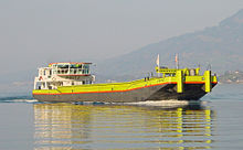
Under separate management, the Autofähre Beckenried-Gersau provides a car ferry service between Beckenried, on the south bank of the lake, and Gersau on the north.
The Rigi, Pilatus, the Bürgenstock, the Stanserhorn, the Buochserhorn, and the two legends, the Urirotstock and the Fronalpstock are attractive panoramic mountains near Lake Lucerne.
Due to the wind in the Reuss Valley, the southern part of Lake Uri between the campground at Gruonbachstrand in Flüelen and Isleten is a center of windsurfing.