Lake Pontchartrain Causeway
[5] The two bridges feature a bascule, which spans the navigation channel 8 miles (13 km) south of the north shore.
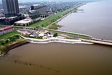
The idea of a bridge spanning Lake Pontchartrain dates back to the early 19th century and Bernard de Marigny, the founder of Mandeville.
[8] On June 16, 1964, six people died when barges tore a gap in the bridge and a bus plunged into the lake.
To alleviate congestion on the south shore, toll collections were eliminated on the northbound span.
[10] The opening of the causeway boosted the fortunes of small North Shore communities by reducing drive time into New Orleans by up to 50 minutes, bringing the North Shore into the New Orleans metropolitan area.
The storm surge was not as high under the causeway as it was near the I-10 Twin Span Bridge, and damage was mostly limited to the turnarounds.
With the I-10 Twin Span Bridge severely damaged, the causeway was used as a major route for recovery teams staying in lands to the north to get into New Orleans.
The causeway reopened first to emergency traffic and then to the general public – with tolls suspended – on September 19, 2005.
The Lake Pontchartrain Causeway is one of seven highway spans in Louisiana with a total length of 5 miles (8.0 km) or more.
[14] Supporters made this claim based on its own definition, i.e. the length of a bridge physically over water, and concluded that the Lake Pontchartrain Causeway spans 23.79 mi (38.28 km),[14] and was therefore the longest.