Lake Superior National Estuarine Research Reserve
The Reserve is operated as a program of the Natural Resources Institute of the University of Wisconsin-Madison Division of Extension.
Surface water runoff from the St. Louis River watershed is the primary source of freshwater into the estuarine system.
Recently, Priority Conservation Opportunity Areas were identified for Wisconsin's Wildlife Action Plan.
Through that process, the wetlands and boreal forest associated with the St. Louis River freshwater estuary complex were identified as an area of continental significance.
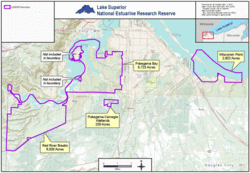
Major site features include several miles of open sand beach and dunes, small interdunal wetlands, and a xeric forest of white and red pines.
The Reserve includes uplands and submerged lands; riparian and riverine habitat; riverine islands; emergent freshwater marshes, interdunal wetlands and scrub swamp; aspen, dry and hardwood forests; and open sand beach and dunes.
Unique to the Reserve System, the Pokegama Bay component, downstream of Red River Breaks, contains one of the largest municipal forests in the United States.
Native American tribal cultural sites are found on Wisconsin Point and throughout the lower St. Louis River freshwater estuary.
Reserve offices and research facilities are on Barker's Island in Superior Bay, part of the Duluth-Superior harbor.