Lake Van
[2] The western portion of the lake is deepest, with a large basin deeper than 400 m (1,300 ft) lying northeast of Tatvan and south of Ahlat.
The Van-Ahtamar portion shelves gradually, with a maximum depth of about 250 m (820 ft) on its northwest side where it joins the rest of the lake.
The lake's southern margin demarcates: a metamorphic rock zone of the Bitlis Massif and volcanic strata of the Neogene and Quaternary periods.
[10] The lake's proximity to the Karlıova triple junction has led to molten fluids of the Earth's mantle accumulating in the strata beneath, still driving gradual change.
However, the level of this threshold has varied over time, as the lake has been blocked by successive lava flows from Nemrut volcano westward towards the Muş Plain.
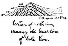
[11] Land terraces (remnant dry, upper banks from previous shorelines) above the present shore have long been recognized.
On a visit in 1898, geologist Felix Oswald noted three raised beaches at 15, 50 and 100 feet (5, 15 and 30 meters) above the lake then, as well as recently drowned trees.
[13] Research in the past century has identified many similar terraces, and the lake's level has fluctuated significantly during that time.
Investigation by a team including Degens in the early 1980s determined that the highest lake levels (72 metres (236 ft) above the current height) had been during the last ice age, about 18,000 years ago.
In 1989 and 1990, an international team of geologists led by Stephan Kempe from the University of Hamburg[a] retrieved ten sediment cores from depths up to 446 m (1,463 ft).
Although these cores only penetrated the first few meters of sediment, they provided sufficient varves to give proxy climate data for up to 14,570 years BP.
[14] A team of scientists headed by palaeontologist Professor Thomas Litt at the University of Bonn has applied for funding from the International Continental Scientific Drilling Program (ICDP) for an akin deeper-drilling project.
The lake, particularly on its urban townscape shore, tempers the climate in the city of Van, where the average temperature in July is 22.5 °C, and in January −3.5 °C.
The archaeologists believe that the fortress, along with other parts of the ancient city that surrounded it at the time, had slowly become submerged over the millennia by the gradually rising lake.
In the uneasy peace between the two empires, local Armenian-Byzantine landowners employed Turcoman gazis and Byzantine akritai for protection.
In the second half of the 11th century Emperor Romanus IV Diogenes launched a campaign to re-conquer Armenia and head off growing Seljuk control.
Diogenes and his large army crossed the Euphrates and confronted a much smaller Seljuk force led by Alp Arslan at the Battle of Manzikert, north of Lake Van on 26 August 1071.
A news article was published by Saadet Gazetesi issue number 1323, dated 28 Shaban 1306 Hijri year, corresponding to 29 April 1889 during the reign of Sultan Abdul Hamid II.
[31] Near the Van Fortress and the southern shore, on Akdamar Island lies the 10th century Cathedral of the Holy Cross, Aghtamar (Armenian: Սուրբ Խաչ, Surb Khach), which served as a royal church to the kingdom of Vaspurakan.
[citation needed] The ruins of Armenian monasteries also exist on the other three islands of Lake Van: Lim, Arter, and Ktuts.
[34] In December 2015, the new generation of train ferries operated by the Turkish State Railways, the largest of their kind in Turkey, entered service in Lake Van.