Lands of Threepwood
The lands of Threepwood were located in the Parish of Beith, at the eastern boundary between East Renfrewshire and North Ayrshire, Scotland.
In 1557 Adam passed the lease to John Hamilton of Stanehouse for "thirteen score of merks, thirty bolls seeds oats, six bolls of bere, four oxen and a brown horse"[4] and a few months later John obtained a feu that passed the lands to the family in perpetuity for an annual payment.
[7] Robert Love may have been their son and is described as being 'portioner of Threepwood' as he sold or sub-feued Townend Farm to Thomas Fulton and Midtoun or Mid Town to William Anderson.
James Love, his son, married Barbara Stewart of Risk in Lochwinnoch parish in 1652 as recorded on a stone inscribed 'J.L.
This arrangement led to small farm towns being established with accommodation for at least four men in six to eight houses, taking practical considerations into account.
[6] In 1858 the settlement is marked with a single roofed building and a ruin that abuts onto the lane leading up to Threepwood House.
[16] In 1858 Town Head is shown as a single building accessed from the west[15] and in 1895 it is roofless,[16] but a new private dwelling has been built at the site in recent times.
[6] Hugh Stevenson was the farmer at Townend of Threepwood Farm in the early 19th century and after his death his sons succeeded him, later however the lands were divided and sold.
Circa 1847 the area was surveyed and divided off from the other portion of the property which was then purchased by Robert Shedden Patrick, Esq., of Trearne and Hazlehead.
[17] John Shedden of Marshalland, called "The Lang Laird" because of his height, married Mary Stevenson of Townend of Threepwood.
John was a tall man, strong and a notorious poacher of hares at a time when poaching was governed by archaic laws.
[18] After several court appearances Jack moved to a large estate in England where he worked as the head gamekeeper, earning a good wage and returning with substantial savings.
On his return he became ironically known as "The Gem keeper" and when he died his poacher friend Thomas Stevenson fired off his gun to the "rict and left" over his grave, much to the surprise of George Colville, the minister at the time.
A busy area in terms of horse drawn transport along Threepwood Road and pedestrian traffic so that the building may have provided accommodation for travellers and/or bleach works employees.
The unusual 'window' at the back resembles the 'Jug' windows found in pubs where a jug or bottle of beer was filled and taken away to be consumed elsewhere as recorded in this poem about 'The Den' at Barkip - The narrow 'layby' on the roadside with a well and small building suggests water and food for horses.
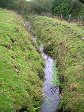
The largest bleach works lay next to a millpond fed by the Cadgerford Burn that supplied water for both the 'bucking' process and power for the waterwheel.
In 1895 the name Sunnyside of Threepwood is used on the map and the dwelling has increased considerably in size with the oldest section lying to the east.
[16] It may be no coincidence that the name 'Sunnyside' is attached to the dwelling as Thomson's map shows that this was the open south facing site of the old bleachfield where the bleached cloth was dried.
[13] Close to Coldhame Cottage on the verge before the turning to Brownmuir Farm is a rare survival, the Weaver's or Threepwood Well, a freshwater spring that exits the rock in a steady flow that runs into a shallow excavation with a stone border, surrounded by heather, ferns, mosses, wild rose, whortleberry, willow moss, etc.
[20] The name of the inflow and outflow burn indicates, as stated, a ford on this old road once used by cadgers or carriers on horseback of goods, including items such as Dunlop cheeses.
Beith's annual fair, called Tennant's or Saint Tinnan's Day, was previously held on the Cuff Hill[28] It was famous for its show, and its Cadger's parade and sale of horses.
[29] The Cuff Hill rocking stone (NS 3827 5542) is a large glacial erratic boulder of basaltic greenstone[30] that some people associate with the Druids.
On Cuff Hill were once located a group of four standing stones, also the Druid's Grave and the likely site of a pre-reformation chapel at Kirklee Green.
Smith records that a Law Mound was located at Threepwood, twelve paces in diameter,[32] however this place name is not marked on OS maps and is seemingly unknown by local inhabitants.