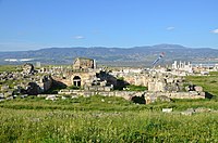
Laodicea on the Lycus
[3] Laodicea is situated on the long spur of a hill between the narrow valleys of the small rivers Asopus and Caprus, which discharge their waters into the Lycus.
It was situated in the ancient region of Phrygia, although some ancient authors place Laodicea in differing provincial territories, not surprising because the precise limits of these territories were both ill-defined and inconstant; for example, Ptolemy[6] and Philostratus[7] call it a town of Caria, while Stephanus of Byzantium describes it as belonging to Lydia.
Laodicea was founded by Antiochus II Theos, king of the Seleucid Empire, in 261-253 BC in honour of his wife Laodice, together with several other cities of the same name.
[12][13] After the Battle of Magnesia in 188 BC, when the Romans defeated the Seleucids, the Treaty of Apamea was signed, which gave control of the whole of western Asia Minor to the Kingdom of Pergamon.
[20][21] The wealth of its inhabitants engendered a taste for the arts of the Greeks, as is manifest from its ruins, and that it contributed to the advancement of science and literature is attested by the names of the sceptics Antiochus and Theiodas, the successors of Aenesidemus (1st century BC),[22] and by the existence of a great medical school.
One of the chiefs of these citizens, Polemon (r. 37 BC - 8 AD), became King of Armenian Pontus (called after him "Polemoniacus") and of the coast round Trebizond.
[24] The city minted its own coins, the inscriptions of which show evidence of the worship of Zeus, Æsculapius, Apollo, and the emperors.
The area often suffered from earthquakes, especially from the great shock that occurred in the reign of Nero (60 AD) in which the town was completely destroyed.
[33] Some Greek manuscripts of the First Epistle to Timothy end with the words: "Written at Laodicea, metropolis of Phrygia Pacatiana".
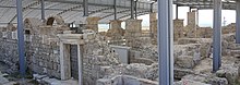
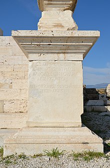
On the eastern side, the line of the ancient wall may be distinctly traced, with the Ephesus gate's remains; streets traverse the town, flanked by colonnades and numerous pedestals.
North of the town, towards the Lycus, are many sarcophagi, with their covers lying near them, partly embedded in the ground, and all having long been rifled.
Unusually, to cross the valley to the south of Laodicea, instead of the usual open channel carried above the level of the city on lofty arches as was the usual practice of the Romans, an inverted siphon was employed consisting of a double pressurised pipeline, descending into the valley and back up to the city.
The low arches supporting the siphon commence near the summit of a low hill to the south of the city where the header tank was located and thence continue to the first terminal distribution tank (castellum aquae) at the edge of the hill of the city, whose remains are visible to the east of the stadium and South Baths complex.
The water was heavily charged with calcareous matter, as several arches were covered with a thick encrustation where leaks occurred later.
The terminal tank has many clay pipes of various diameters for water distribution on the north, east, and south sides, which were replaced in time because of the choking by sinter.
A second distribution terminal and sedimentation tank are visible 400 m north of the first, to which it was connected via another siphon of travertine blocks, and this one was bigger and supplied most of the city.
Towards the west are considerable remains of an underground passage by which chariots and horses could be admitted into the arena, with a long inscription over the entrance.