Lasham
The parish covers an area of 1,797 acres (727 ha) and has an average elevation of 560 feet (170 m) above sea level.
The name "Lasham" is thought to have originated from the Old English words læsc (a cleared plot of land) and ham (homestead or village).
[3] The village of Lasham was originally held as an allodial title under Edward the Confessor and became part of the Crown's possessions in 1086, assessed at 2½ hides.
Upon his death in 1297, his nephew, Richard de Burgh, the third Earl of Ulster, inherited the fee held by John Dabernon.
The Camoys family eventually lost the estate to the Prior of God's House, Portsmouth, in exchange for lands in Dorset in 1268.
[4] In 1315, Idonea and her husband, John de Crumbwell, arranged for their half-fee in Lasham to be settled on them for life, with remainders to the Despenser family.
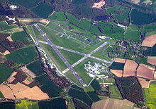
This road was made of large concrete "sets" and was built by Italian prisoners of war who were housed in a camp at Thedden Grange southwest of Bentworth.
Previously, for some 200 years, Lasham was part of the Herriard Park estate [2] (which still exists today to the north of the parish).
When the plans became known, Sir George Jeffreys MP wrote a letter of objection which was published in the London Times newspaper on 7 October 1941.
Avenue Road, mentioned above and running on the north side of Lasham Airfield, connects the A339 to the B3349 at the Golden Pot public house at the top of the hill between Alton and Odiham.