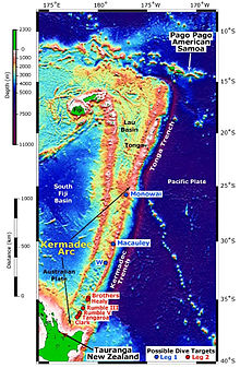
Lau Basin
The rifting was initially caused by extension until 6 million years ago, by which time seafloor spreading started in this region and eventually formed the Lau Basin between the separated ridges.
[4] In the north the basin reaches its maximum width of 500 km (310 mi) with a triangular shape to the south understood to be the result of the southward propagation of the main extensional centers and their asymmetric, predominantly westward opening.
[13] From the north of the CLSC we have a northeast orientated Lau Extensional Transform Zone (LETZ) which joins up to the Peggy Ridge which is a fairly linear SW to NE orientated ridge greater than 200 km (120 mi) in the central Lau Basin[14](Labelled PR in diagram of basin on this page).
[15] There is considerable complexity at the northern part of the Lau Basin where presently five independent oceanic tetectonic plates are interacting.
[17] A prominent NW-trending formation of young volcanic structures that includes the Niuafo'ou shield volcano crosses the northern Lau Basin approximately 75 km (47 mi) west of the MTJ and is called the Western Rift Margin (WRM).
This western region has a different composition because it was formed by extension and rifting between the Lau and Tonga ridges before seafloor spreading started.
[18] The southern basin volcanics and that of the ʻAta volcano can be associated with recycling from the subducted portions of the Louisville Seamount Chain.
[13] To the south the lavas in this part of the Lau Basin are more arc-like than the MORB at the ELSC, with basalt and andesite present.
This melt supply may still be continuing today as indicated by a low-velocity anomaly in the upper mantle beneath the western Lau Basin.
This fertile mantle then encounters the water released from the dehydrated subducting Pacific slab and undergoes partial melting.
An upward flow of the depleted layer is then induced by back-arc spreading and slab subduction towards corner region where the mantle is hydrated.
The ELSC located right on top of the highly depleted mantle thus experiences a diminished magma supply which results in a thinner layer of crust and a faster spreading rate.
The CLSC, on the other hand, has thicker crust because it overlies the fertile mantle that is largely removed from effect of the volcanic front.
[22] In the northern Lau Basin, the extensional motion between the reference points of Australia and Tonga is accommodated by multiple zones of active rifting and spreading that are located along the boundaries of the Niuafo'ou microplate.
[3] These are so complex, especially towards the north that other smaller microplates may currently exist and certainly some of the plate boundaries are zones of deformation or for other reassons are ill defined.
[25] The west dipping Pacific slab whose bed rock is about 110 millions years old is presently being subducted under the independent Tonga microplate whose spreading center from the Australian Plate are those of the southern Lau Basin.
To the east some islands of Tonga are located in the latitudinal range of the ELSC, notably in view of its recent eruptive history Hunga Tonga–Hunga Haʻapai, 80 km (50 mi) away.
[8] It has been suggested that carbonate sediments deposited on a previously subducted Louisville Seamount Chain volcano may have been a factor in the explosive nature of the 2022 eruption.
[27] ʻAta is about 50 km (31 mi) east of the Valu Fa Ridge[8] and compositional analysis of its volcanics have identified that these are associated with the subducted portions of the Louisville seamounts.
[9] However low‐magnitude seismicity (i.e. mainly Mw less than 5) has been recorded along the active spreading centers in the Lau Basin by ocean bottom seismometers.

C-ELSC - Central Eastern Lau Spreading Center
CLSC - Central Lau Spreading Center
FRSC - Fonualei Rift and Spreading Center
FSC - Futuna Spreading Center
ILSC - Intermediate Lau Spreading Center
LETZ - Lau Extensional Transform Zone
MTJ - Mangatolu Triple Junction
NELSC - North-East Lau Spreading Center
NWLSC - North-West Lau Spreading Center
VFR-Valu Fa Ridge

