Lawton, Oklahoma
According to the 2020 census, Lawton's population was 90,381, making it the sixth-largest city in the state, and the largest in Western Oklahoma.
Lawton's landscape is typical of the Great Plains, with flat topography and gently rolling hills, while the area north of the city is marked by the Wichita Mountains.
The city's proximity to the Fort Sill Military Reservation, formerly the base of the Apache territory before statehood, gave Lawton economic and population stability throughout the 20th century.
[11] Although Lawton's economy is still largely dependent on Fort Sill, it has grown to encompass manufacturing, higher education, health care, and retail.
Interstate 44 and three major United States highways serve the city, Lawton-Fort Sill Regional Airport connects Lawton by air, while Greyhound Lines and the Lawton Area Transit System provide intercity and local bus service respectively.
In the 16th century, Spanish explorer Francisco Vásquez de Coronado visited in 1541, beginning European contact.
Following the Civil War, during which most of the Southeast tribes had allied with the Confederacy, in 1867, the United States required new treaties of peace.
In 1867, under the Medicine Lodge Treaty, it allotted the southwest portion of former Choctaw and Chickasaw lands to the Comanche, Kiowa, and Apache tribes.
[13][14] Fort Sill was established in 1869 after the American Civil War and commanded by Major General Philip Sheridan.
[15] In 1874, the Red River War broke out in the region when the Comanche, Kiowa, and Southern Cheyenne left their Indian Territory reservation.
Attrition and skirmishes by the US Army finally forced the return of the tribes to Indian Territory in June 1875.
[15] In 1891, the United States Congress appointed a commission to meet with the tribal leaders and come to an agreement allowing White settlement.
Years of controversy and legal maneuvering ensued before President William McKinley issued a proclamation on 4 July 1901, that gave the federal government control over 2,000,000 acres (8,100 km2) of "surplus" Indian lands that remained after allotments of communal tribal lands to individual households under the Dawes Act.
[16][17] Under other legislation, the United States through the Dawes Commission allotted communal lands as plots to individual households of tribal members, selling off what remained as "surplus".
These actions extinguished the tribal claims to communal lands, a condition needed for the admission of Oklahoma as a state in 1907.
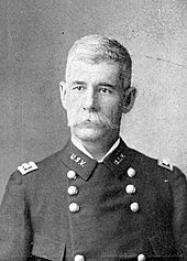
The town was named for Major General Henry W. Lawton, a quartermaster at Fort Sill, who had taken part in the pursuit and capture of Apache chief Geronimo.
[18] The city was opened to settlement through an auction of town lots beginning on 6 August 1901, which was completed 60 days later.
The availability of 5 million US gallons (19,000 m3) of water from Lake Lawtonka, just north of Fort Sill, was a catalyst for the War Department to establish a major cantonment named Camp Doniphan.
[22] Similarly, the US response in World War II stimulated activity and expansion at Fort Sill and Lawton.
[25][26] On 1 March 1964, the north section of the H. E. Bailey Turnpike was completed, connecting Lawton directly to Oklahoma City, the capital.
[31] Lawton lies in an area typical of the Great Plains, with prairie, few trees, and flat topography with gently rolling hills.
[34] In the south sections of the city, Permian Garber Sandstone is commonly found with some Hennessey Group shale.
[32] Lawton is located squarely in the area known as Tornado Alley and is prone to severe weather from late April through early June.
Of the for-profit wage and salary workers, 659 (1.9% of the total Lawton civilian workforce) were employees of their own corporations.
[55] Outdoor exhibits include a replica of the Red River Trading Post, the original Blue Beaver schoolhouse, and Elgin Train Depot with a Frisco locomotive.
[67] The mayor, who is elected at-large every three years, presides and sets the agenda of the City Council, but is primarily ceremonial as a head of government.
[99] Lawton is part of a bistate media market that also includes the nearby, larger city of Wichita Falls, Texas; the market, which encompasses six counties in southwestern Oklahoma and 10 counties in western North Texas, has 152,950 households with at least one television set, making it the 148th-largest in the nation as of the 2016–2017 season, according to Nielsen Media Research.
[101] KSWO-TV (channel 7), an ABC affiliate (which also carries affiliations with MeTV and Telemundo on digital subchannels), is the only broadcast television station in the market that is licensed to Lawton, and its local news programming maintains a primary focus on southwestern Oklahoma in its coverage.
Other major thoroughfares include US Highway 277 and 281, which parallels the H. E. Bailey Turnpike to Wichita Falls to the south and leads to regional towns of Anadarko and Chickasha, respectively, to the north, and OK-7, which connects Lawton to Duncan.
At present, it offers daily American Eagle flights to Dallas/Fort Worth International Airport, and is also used for military transport.