Lea Valley
The main underlying geological formation of the lower part of the Lea catchment, south of Hoddesdon, is Eocene London Clay.
However, large areas of these formations are overlain by much more recent Quaternary formations, including Clay-with-Flints (on the Chalk), till and other glacial deposits (mostly in the upper part of the catchment), and fluvial sand, gravel and alluvium (in the lower parts of today's valleys, but also on some higher ground in east Hertfordshire, Middlesex and west Essex, where such deposits were laid down by the pre-glacial "proto-Thames"[2] and its former tributaries).
The relief of the upper part of the Lea catchment is one of gently rolling hills, which are divided by the valleys that fan out to the north and north-west from an area between Hertford and Hoddesdon.
From there, the land rises on either side to an altitude of around 120 metres, to gravel-capped plateaus in Hertfordshire (Northaw) and Middlesex (Southgate) to the west, and to Essex (Epping Forest) in the east.
Until the Anglian glaciation about 450,000 years ago, the Thames flowed north-eastward past Watford, through what is now the Vale of St Albans, then eastwards towards Chelmsford and the North Sea.
Further north, the newly formed lower Lea was fed by rivers which, as mentioned above, had flowed directly into the proto-Thames prior to the Anglian glaciation.
These rivers - the upper Lea, the Mimram, the Beane, the Rib, the Ash and the Stort - today follow courses which are mostly similar to those of their pre-Anglian predecessors.
[8]) Prior to the Anglian glaciation, a "proto-Mole-Wey" river was flowing northwards from the Weald and North Downs, through the "Finchley depression", to join the proto-Thames somewhere around Hoddesdon.
[9] Just prior to the arrival of the Anglian ice sheet in the Thames basin, this proto-Mole-Wey river appears to have been flowing over a wide, low-gradient valley floor between Palmers Green and Hoddesdon at what is today an altitude of around 60 metres.
In any case, even if all or some of the water being conveyed by the proto-Thames as it flowed north-east through the Vale of St Albans was diverted southwards from around Hoddesdon by an advancing Anglian ice sheet, this could only have been for a brief (geologically speaking) period, because the ice then progressed further to the south and caused the above-mentioned complete diversion of the Thames to its more southerly course of today.
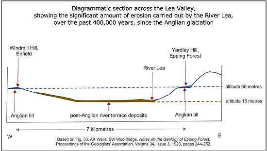
[6] In addition, it is clear that the River Lea alone has been powerful enough to cause significant erosion below the surface across which the Anglian ice sheet flowed and on which it left till and other deposits.
It has been suggested that the River Lea has been "tilted...into its eastern bank" by "a north-south monocline" which was established "at least as early as the beginning of Eocene times".
To the south the wider expanse of Greater London includes the floodplain settlements of Enfield Lock, Enfield Highway, Brimsdown, Ponders End, Edmonton, Tottenham, Tottenham Hale, Clapton, Lea Bridge, Leyton, Hackney Wick, Old Ford, Bow, Stratford, West Ham, Bromley-by-Bow, Canning Town and Leamouth.
The valley is also followed by two routes of what became the Great Eastern Railway and had important marshalling yards and locomotive works at Temple Mills.
In the 19th century the lower Lea became an important area for the manufacture of chemicals, in part based on the supply of by-products such as sulphur and ammonia from the Gas Light and Coke Company's works at Bow Common.
In the 20th century the combination of transport, wide expanses of flat land and electricity from riverside and canal-side plants such as Brimsdown, Hackney, Bow and West Ham led to expansion of industries including for example Enfield Rolling Mills and Enfield Cables, Thorn Electrical Industries, Belling, Glover and Main, MK Electric, Gestetner, JAP Industries, Ferguson Electronics, Hotpoint, Lesney (original makers of Matchbox toys), a Ford components (later Visteon) plant and Johnson Matthey.