Leilani Estates, Hawaii
Leilani Estates is a census-designated place (CDP) in Hawaiʻi County, Hawaii, United States located in the District of Puna.
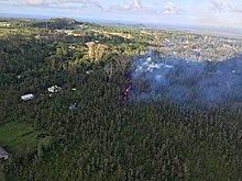
The 2018 lower Puna eruption of Kīlauea Volcano, which occurred within and around the subdivision, claimed many homes and displaced an unknown number of Leilani Estates residents.
[6] Accessing the entire resulting solid lava rock flow field has been prohibited, as per the Mayor's 12/6/18 Emergency Proclamation,[7] with fines up to $5,000 for violations.
According to the United States Census Bureau, the CDP has a total area of 4.03 square miles (10.45 km2), all of it land.
[10] Of the 24 total volcanic fissure vents that formed during the event, 14 erupted lava to varying degrees within Leilani Estates.
[11] ʻAhuʻailāʻau (initially designated Fissure 8) on Luana St. was the dominant vent that produced the most output of lava, with fountaining as high as 330 feet [12] and flow front advancement as fast as 76 m/h [13] as it reached the ocean miles below Leilani Estates.