Lethbridge
The nearby Canadian Rocky Mountains contribute to the city's warm summers, mild winters, and windy climate.
Cultural venues in the city include performing art theatres, galleries, museums, gardens, and sports centres.
The Blackfoot referred to the area as Aksaysim ("steep banks"), Mek-kio-towaghs ("painted rock"), Assini-etomochi ("where we slaughtered the Cree") and Sik-ooh-kotok ("coal").
The North-West Mounted Police, sent to stop the trade and establish order,[12] arrived at Fort Whoop-Up on October 9, 1874.
[12] Lethbridge's economy developed from drift mines opened by Nicholas Sheran in 1874 and the North Western Coal and Navigation Company in 1882.
[14][15] By the turn of the century, the mines employed about 150 men and produced 300 tonnes (330 short tons) of coal each day.
[12] In 1896, local collieries were the largest coal producers in the Northwest Territories,[16] with production peaking during World War I.
[18] The rail industry's dependence on coal and the Canadian Pacific Railway's (CPR) efforts to settle southern Alberta with immigrants boosted Lethbridge's economy.
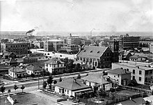
[19] Between 1907 and 1913, a development boom occurred in Lethbridge, making it the main marketing, distribution and service centre in southern Alberta.
[12] After World War II, irrigation of farmland near Lethbridge led to growth in the city's population and economy.
[12] In 2015 American musician Marilyn Manson was assaulted by a local resident in the city's Denny's after the singer allegedly insulted a woman in the restaurant in the early hours of the morning.
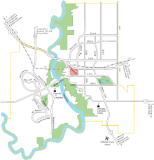
[20] The city of Lethbridge is located at 49.7° north latitude and 112.833° west longitude and covers an area of 127.19 km2 (49.11 sq mi).
It has the oldest population of the three areas, is home to multiple industrial parks and includes the former Hamlet of Hardieville, which was annexed by Lethbridge in 1978.
[27] Its high elevation of 929 m (3,048 ft) and close proximity to the Rocky Mountains provides Lethbridge with cooler summers than other locations in the Canadian Prairies.
All other Christian denominations and Christian-related traditions made up 9.6%, including a large population of The Church of Jesus Christ of Latter-day Saints adherents (5.8%).
Other common mother tongues were Spanish (1.6%),Tagalog (1.4%), Nepali (1.0%), German (0.9%), French (0.8%), Chinese Languages (0.7%), Arabic (0.7%) and Dutch (0.6%).
It has a trading area population of 341,180, including parts of British Columbia,[30] and provides jobs for up to 86,000 people who commute to and within the city from a radius of 100 km (62 mi).
From its founding in 1935, Canadian Freightways based its head office there until moving operations to Calgary in 1948, though its call centre remains in Lethbridge.
[87] Lethbridge provides municipal water to Coaldale, Coalhurst, Diamond City, Iron Springs, Monarch, Shaughnessy and Turin.
[90] Two years later, the city joined in a partnership with 24 other local communities to create an economic development alliance called SouthGrow, representing a population of over 140,000.
As a fully independent non-profit society, Vox Musica continues to rehearse and perform at Southminster United Church and around the community.
Nikka Yuko Japanese Garden in south Lethbridge was opened in 1967 as part of a Canadian centennial celebration attended by Japan's Prince and Princess Takamatsu.
401 randomly selected people participated in this survey and 43 percent of them identified the presence of ARCHES SCS as the top concern.
[117] Lethbridge has designated 16 percent of the land within city boundaries as parkland, including the 755 hectares (1,870 acres) Oldman River valley parks system.
[118] It has facilities for field sports, numerous baseball diamonds, the Spitz Stadium,[119] the Nicholas Sheran Park (a disc golf course), two skateparks, a BMX track, a climbing wall, a dozen tennis courts, and seven pools.
[123] Phase 2 of this project The Cor Van Ray YMCA opened in May 2019 [124] and includes a field house with basketball courts and a 300m running track, as well as an aquatics centre with slides and a wave pool.
[129] One member of parliament (MP) representing federal electoral district of Lethbridge sits in the House of Commons in Ottawa, and two members of Alberta's legislative assembly (MLAs), representing Lethbridge-East (UCP) and Lethbridge-West (NDP), sit in the Alberta Legislature Building in Edmonton.
The Parks and Recreation department maintains the citywide, 30 km (19 mi) pedestrian / cyclist Coal Banks Trail system.
[138] This infrastructure and its location on the CANAMEX Corridor has helped make Lethbridge and its freight depots a major shipping destination.
The Palliser School Division, which is based in Lethbridge, administers public primary and secondary education in the outlying areas.