Lewes Road, Brighton
Bus lanes, cycle paths and the Vogue Gyratory—"a fiendish maze of one-way systems, roundabouts and crossings",[2] named after a pornographic cinema—add to the road's complexity.
"[3] Sitting at the bottom of a dry valley with hills on each side, particularly alongside the northern part of the route, the road is sheltered and hidden from distant views.
[3] The road's character changes substantially along its length, and the city council considers it to have three separate character areas: the central fringe (The Level to the Vogue Gyratory), largely Victorian in character with a mixture of housing and retail and an "uncoordinated urban realm"; the inner suburban area (Vogue Gyratory to Natal Road), dominated by the dual carriageway and "hostile to pedestrians", with council flats, privately rented terraced houses, industrial buildings and the large university buildings; and outer suburban, consisting mostly of rented housing, more university buildings and some open space, giving "a very green approach to the city".
[4] The 8.05-acre (3.26 ha) area of marshy open land now known as The Level was the meeting point of three winterbournes, including one which occasionally surfaced along the dry valley where Lewes Road runs.
Scattered farm cottages near Lewes Road were the only buildings in the valley until Brighton Corporation developed it for council housing from 1950 as the Coldean estate.
The historic route to Lewes ran in a more easterly direction on a drove road across the South Downs; it still exists as footpaths and byways.
[14] The present road, which takes a north–northeasterly course along a valley from the centre of Brighton as far as Falmer, existed by the 18th century and became a turnpike in 1770; the toll gate at the Lewes end survives, but that at Brighton—near the Bear Inn—is no longer standing.
[15] Development of Lewes Road started at the south end, closest to the centre of Brighton, and was confined to the east side at first because the open ground of The Level was to the west.
Facilities included accommodation, a hospital and a riding school, and "a small community grew up" on the east side of the road in connection with the barracks.
An earlier proposal for a mixed residential and commercial development, announced in 2003,[22] foundered during the 2007–2008 financial crisis; an alternative scheme was put forward by the University of Brighton in September 2009.
[26] As part of the £300 million scheme, the university announced in late 2021 that it would close its three sites at Eastbourne and consolidate their facilities at Lewes Road.
This electrical engineering company expanded to become one of Brighton's largest employers, and it opened several factories along Lewes Road in the interwar period.
The development of Moulsecoomb was part of a council policy of "providing good family housing in the more healthy environments away from the town centre".
[32] Wartime restrictions and bomb damage in central Brighton meant that by the 1950s much more new housing was needed, and the council's policy of developing outlying estates resumed.
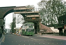
[32] Between 1869 and 1976 Lewes Road was crossed by a railway viaduct carrying the Kemp Town branch line above the valley floor.
[39] In 1926, during the general strike of that year, tensions linked to the proposed operation of local tram services with volunteer labour came to a head in the Battle of Lewes Road on 11 May, when "vicious struggles" broke out between 4,000 strikers and police officers.
[41] Immediately to the north are the villas of Richmond Terrace—also designed by Wilds senior and junior in 1818, and an example of the speculative housing development which was rife in Brighton during the early 19th century.
[47] A cinema, originally the People's Picture Palace but latterly known as the Arcadia, stood nearby from 1910 until 1957;[53] the local Labour Club stands on the site.
The work was part of a larger scheme to turn the full length of Lewes Road into an "academic corridor", linking the Falmer, Moulsecoomb and Brighton (Grand Parade) campuses of the two universities.
[1] In July 2023 it was announced that the southern section of Lewes Road, between Elm Grove and the Vogue Gyratory, would be turned into a red route in spring 2024.
[53] A "fiendish maze of one-way systems, roundabouts and crossings", it has been described as "an issue that was identified by almost everybody in [council] consultation events" and "a fairly brutal place ... [especially] if you're a pedestrian".
[2] Radical redevelopment plans were prompted by the discovery in 2005 that the gyratory was one of the most polluted sites in the city: it was even suggested that the whole area could be demolished (including the Sainsbury's supermarket) and laid out again from scratch.
[81] Plans were also made to extend the tram tracks north from the depot along Lewes Road towards the developing Moulsecoomb estate, and the council and central government (who were required to pass a Light Railway Order) authorised an extension in 1920; but Brighton Corporation Tramways never took up the option and the permission lapsed.
[3] The growth in passenger numbers on routes along Lewes Road serving the universities was greater than on any other part of the Brighton & Hove bus network between 1986 and 2010.
[86] In 1996 a service of three buses per hour was introduced between central Brighton and the Coldean and Hollingbury estates,[87] running the full length of Lewes Road and replacing an older route whose frequency had fluctuated.
[89] The Moulsecoomb and Bevendean estates are served by regular buses which travel to the city centre direct down Lewes Road.
[96] Although it is "the only green space along the route" until Wild Park at Moulsecoomb is reached, its location on the busy road remote from housing means it is underused.
[97] The Extra Mural and Woodvale cemeteries occupy a sheltered, well-wooded hillside above Lewes Road and have been described as among "the most delightful spots in the whole of Brighton";[98] they are open to the public, and have been considered "one of the most pleasant and quiet places in Brighton in which to take a walk" since the Victorian era, when a guidebook was published with suggested walks around the Extra Mural Cemetery.
[100] Further north, at Moulsecoomb, Wild Park was bought by Brighton Corporation in 1925 to preserve it from development and has been left as open downland, apart from the construction of some sports pitches.
[101] Wild Park and Hollingbury Hill together make up the city's largest Local nature reserve (LNR), covering 593 acres (240 ha) west of the Lewes Road.