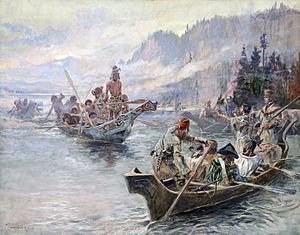
Lewis and Clark Expedition
The Corps of Discovery was a select group of U.S. Army and civilian volunteers under the command of Captain Meriwether Lewis and his close friend Second Lieutenant William Clark.
The campaign's secondary objectives were scientific, economical and humanitarian, i.e., to document the West's biodiversity, topography and geography and to establish positive trade relations with (potentially unknown) Native American tribes.
He also placed special importance on declaring US sovereignty over the land occupied by the many different Native American tribes along the Missouri River, and getting an accurate sense of the resources in the recently completed Louisiana Purchase.
Mackenzie's accounts in Voyages from Montreal (1801) informed Jefferson of Britain's intent to establish control over the lucrative fur trade of the Columbia River, convincing him of the importance of securing the territory posthaste.
[11][12] In Philadelphia, Israel Whelen, purveyor of public supplies, purchased necessities for the expedition with a list provided by Lewis; among the items found were 193 pounds of portable soup, 130 rolls of pigtail tobacco, 30 gallons of strong spirit of wine, a wide assortment of Native American presents, medical and surgical supplies, mosquito netting and oilskin bags.
[18] In 1803, Jefferson commissioned the Corps of Discovery and named Army Captain Meriwether Lewis its leader, who then invited William Clark to co-lead the expedition with him.
[19] Lewis demonstrated remarkable skills and potential as a frontiersman, and Jefferson made efforts to prepare him for the long journey ahead as the expedition was gaining approval and funding.
[23][24] From Benjamin Smith Barton, Lewis learned how to describe and preserve plant and animal specimens; from Robert Patterson, refinements in computing latitude and longitude, and Caspar Wistar covered fossils, and the search for possible living remnants.
Le Page's description of Moncacht-Apé's route across the continent neglects to mention the need to cross the Rocky Mountains, and it might be the source of Lewis and Clark's mistaken belief that they could easily carry boats from the Missouri's headwaters to the westward-flowing Columbia.
[40] While accounts vary, it is believed the Corps had as many as 45 members, including the officers, enlisted military personnel, civilian volunteers, and York, an African-American man enslaved by Clark.
[43][44][45] During the final week of August, Lewis and Clark reached the edge of the Great Plains, a place abounding with elk, deer, bison, pronghorn and beavers.
The Lewis and Clark Expedition established relations with two dozen Native American nations, without whose help the group would have risked starvation during the harsh winters and/or become hopelessly lost in the vast ranges of the Rocky Mountains.
[58][59] The expedition faced the beginning of its second bitter winter camped on the north side of the Columbia River, in a storm-wracked area Clark called Dismal Nitch.
[60] Knowing that maritime fur traders sometimes visited the lower Columbia River, Lewis and Clark repeatedly asked the local Chinooks about trading ships.
[69] In March 1804, before the expedition began in May, the Spanish in New Mexico learned from General James Wilkinson[note 2] that the Americans were encroaching on territory claimed by Spain.
[74][75] Their visit to the Pacific Northwest, maps, and proclamations of sovereignty with medals and flags were legal steps needed to claim title to each indigenous nation's lands under the Doctrine of Discovery.
[82] Paul Allen edited a two-volume history of the Lewis and Clark expedition that was published in 1814, in Philadelphia, but without mention of the actual author, banker Nicholas Biddle.
One of the expedition's primary objectives as directed by President Jefferson was to be a surveillance mission that would report back the whereabouts, military strength, lives, activities, and cultures of the various Native American tribes that inhabited the territory newly acquired by the United States as part of the Louisiana Purchase and the northwest in general.
They were also provided with various gifts of medals, ribbons, needles, mirrors, and other articles which were intended to ease any tensions when negotiating their passage with the various Native American chiefs whom they would encounter along their way.
[86][87][88][89] The seven native tribes that comprised the Lakota people controlled a vast inland empire and expected gifts from strangers who wished to navigate their rivers or to pass through their lands.
Lewis took a firm stand, ordering a display of force and presenting arms; Captain Clark brandished his sword and threatened violent reprisal.
[86][87][88][89] As the expedition encountered the various Native American tribes during the course of their journey, they observed and recorded information regarding their lifestyles, customs and the social codes they lived by, as directed by President Jefferson.
After many encounters and camping in close proximity to the Native American nations for extended periods of time during the winter months, they soon learned first hand of their customs and social orders.
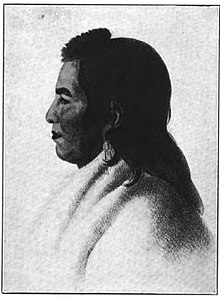
[93] Sacagawea, sometimes spelled Sakajawea or Sakagawea (c. 1788 – December 20, 1812), was a Shoshone Native American woman who arrived with her husband and owner Toussaint Charbonneau on the expedition to the Pacific Ocean.
On February 11, 1805, a few weeks after her first contact with the expedition, Sacagawea went into labor which was slow and painful, so the Frenchman Charbonneau suggested she be given a potion of rattlesnake's rattle to aid in her delivery.
"[97] The sight of a woman and her infant son would have been reassuring to some indigenous nations, and she played an important role in diplomatic relations by talking to chiefs, easing tensions, and giving the impression of a peaceful mission.
They also learned and recorded much about the language and customs of the Native American tribes they encountered, and brought back many of their artifacts, including bows, clothing and ceremonial robes.
In the course of their journey, they acquired a knowledge of numerous tribes of Native Americans hitherto unknown; they informed themselves of the trade which may be carried on with them, the best channels and positions for it, and they are enabled to give with accuracy the geography of the line they pursued.
[107] Lewis and Clark returned from their expedition, bringing with them the Mandan Native American Chief Shehaka from the Upper Missouri to visit the "Great Father" in Washington.
Campsite Lewis and Clark in Camp Sandy Beach at Yawgoog Scout Reservation in Rockville, Rhode Island also honors both explorers.