Lhokseumawe
The area is linked to the emergence of the kingdom of Samudera Pasai around the 13th century, which later came under the sovereignty of Sultanate of Aceh in 1511.
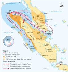
Later, during its golden era, in the 17th century, its territory and political influence expanded as far as Satun in southern Thailand, Johor in Malay Peninsula, and Siak in what is today the province of Riau.
As was the case with most non-Javan pre-colonial states, Acehnese power expanded outward by sea rather than inland.
During the reign of Sultan Iskandar Muda in the 17th century, Aceh's influence extended to most of Sumatra and the Malay Peninsula.
Aceh allied itself with the Ottoman Empire and the Dutch East India Company in their struggle against the Portuguese and the Johor Sultanate.
Acehnese military power waned gradually thereafter, and Aceh ceded its territory of Pariaman in West Sumatra to the Dutch in the 18th century.
In the second decade of the 20th century, among the entire mainland of Aceh, a small island about 11 km2 widely separated by Krueng Cunda River.
32 of 1986 Establishment of the City of Lhokseumawe signed by President of Indonesia Suharto, which was inaugurated by the Minister of Roestam Soeparjo country on 31 August 1987.
Lhokseumawe City is located between 4˚ - 5˚ North Latitude and 96˚ - 97˚ East Longitude with an average altitude of 13 metres above sea level.
Lhokseumawe was given the status of an independent city (separate from North Aceh Regency, which surrounds it on all the landward sides) based on Law Number 2 of 2001, dated 21 June 2001.
Lhokseumawe City is an urban area surrounded on the landward side by Aceh Utara Regency and is located on the northeast coast of Sumatra.