Licancabur
Licancabur (Spanish pronunciation: [likaŋkaˈβuɾ]) is a prominent, 5,916-metre-high (19,409 ft) stratovolcano on the Bolivia–Chile border in the Central Volcanic Zone of the Andes.
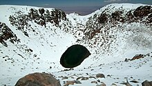
Although no historical eruptions of the volcano are known, lava flows extending into Laguna Verde have been dated to 13,240 ± 100 before present and there may be residual heat in the mountain.
[2] Today it is of interest for research on animal health, remote sensing, telecommunication and the fact that the environment around Licancabur may be the closest equivalent to Mars that exists on Earth,[12][13][14] while current conditions at its lakes resemble those believed to have existed at former lakes on Mars.
[18] The frontier between Bolivia and Chile goes over Licancabur[c];[20] the Chilean portion is in the Antofagasta Region[18] and the Bolivian in the Potosí Department.
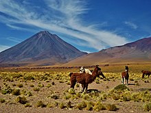
[21] San Pedro de Atacama is 32 kilometres (20 mi) west[2] of Licancabur while the adjacent region in Bolivia is largely uninhabited.
[40] This subduction is ongoing at a rate of 6.6 centimetres per year (2.6 in/year) and is responsible for the volcanism in the Andes,[41] as fluids emanating from the downgoing plate trigger melting within the overlying asthenosphere.
[42] The Andean Central Volcanic Zone (CVZ) extends from southern Peru to cover Bolivia, Chile and Argentina, and contains the highest volcano in the world—Ojos del Salado.
[20] The basement contains intrusions of Paleozoic and sedimentary rocks of Mesozoic age,[46] forming the "Antofalla domain" of the Arequipa-Antofalla tectonic block that originated separately from South America.
[52] Faults associated with the Calama-Olacapato-El Toro lineament cut through the basement in southeast direction[20] and probably influenced the growth of Licancabur and Juriques.
[56] The main phenocryst phase is plagioclase while amphibole, clinopyroxene, iron-titanium oxides, olivine and orthopyroxene are subordinate.
[2] Licancabur is built from magma formed through the melting of altered oceanic crust[57] in the slab at 50–100 kilometres (31–62 mi) depth,[58] which in turn leads to melting in the mantle wedge around 100–200 kilometres (62–124 mi) depth[58] that gives rise to the Licancabur magmas.
[57] Magma mixing,[59] assimilation of continental crustal rocks and fractional crystallization of amphibole and garnet would explain trace element patterns.
[59] The climate is cold, dry and windy with low atmospheric pressure and large day-night temperature differences.
[62] The Atacama Desert is one of the driest on Earth,[63] and as a result,[64] snow cover on Licancabur is ephemeral[2] and there are no glaciers.
[66] Periglacial phenomena, such as frost weathering, inactive rock glaciers and solifluction, have been reported from neighbouring mountains.
[67] The region of the Altiplano next to Llano de Chajnantor and the Cordillera Domeyko likely has Earth's highest insolation rate.
[74] The fauna includes birds (such as black-hooded sierra finch, black-winged ground dove and puna tinamou),[75] frogs (Rhinella spinulosa),[76] insects (butterflies,[72] cuckoo bees[f] and flies),[72] lizards (Liolaemus audituvelatus, L. barbarae, L. constanzae, L. fabiani and L. puritamensis),[78] mammals (Andean hairy armadillo,[79] chinchilla,[72] culpeo, guanaco, southern vizcacha and vicuña)[80] and toads (Telmatobius vilamensis).
[81] In Chile, there were plans to create a protected area including Licancabur and El Tatio, but as of 2018[update] no progress had been made.
[20][45] Activity at Licancabur impacted the environment at Laguna Verde, where the concentration of silicon dioxide and other oxides in the water increased.
[86] Licancabur is thus considered to be potentially active,[66] although SERNAGEOMIN deems it to be low-hazard, and as of 2023[update] placed it as the 68th most dangerous volcano in Chile, out of a total of 87.
[89] It includes a ceremonial platform[90] and multiple structures with mostly semicircular or rectangular shapes,[91] all in the eastern part of the crater.
[96] Tambo de Licancabur has been interpreted either as a site where, during festivities, people who could not ascend the mountain congregated[108] – a base camp, corpahuasi[109] – or as a tambo, an Inca waystation, on the road between San Pedro de Atacama and Inca territories in present-day Bolivia.
[111] The archaeological sites on Licancabur are sometimes interpreted as part of a lookout system for the region,[112][113] or as a symbol of Inca dominance in the San Pedro de Atacama area.
When Inca fled from white people to Licancabur, they hid their treasures, and the waters of the lake turned bitter and its colour green.
Poor weather conditions can quickly develop, and ascending can be difficult given the unstable slopes on the upper cone.