Lichtenfels, Bavaria
The hilly landscape is called Gottesgarten am Obermain ("God's garden on the upper Main"), referring to the Basilica of the Fourteen Holy Helpers and Banz Abbey.
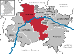
The district of Lichtenfels lies in the western part of the government region (Regierungsbezirk) of Oberfranken (Upper Franconia).
The southern bank of the Main stretches up to the mountain range of the Franconian Jura (Fränkische Alb) beneath the Staffelberg close to Bad Staffelstein.
The town is divided into several districts: Buch am Forst, Degendorf, Eichig, Gnellenroth, Hammer, Isling, Klosterlangheim, Kösten, Köttel, Krappenroth, Lahm, Mistelfeld, Mönchkröttendorf, Oberlangheim, Oberwallenstadt, Reundorf, Roth, Rothmannsthal, Schney, Schönsreuth, Seehof, Seubelsdorf, Stetten, Stöcken, Tiefenroth, Trieb, Unterwallenstadt und Weingarten.
This name they obtained from the Thirty Years' War (1618–1648), from attempting to retrieve hidden sunken treasures in a pond, which they could not empty out due to rapidly running groundwater.
The basket makers in the surrounding upper Maintal area brought their products to trade in Lichtenfels, which was and is the biggest retail market.
After the Second World War Lichtenfels was the main remaining basket dealer and today as an exclusive exporter of the braiding manufactures.