Ligne de Sceaux
In 1838, Jean-Claude-Républicain Arnoux, a graduate of the École polytechnique, proposed a technical solution to improve the speed of trains in curves, while reducing wear on the rails and wheels.
In order to implement his system, Arnoux secured the adoption of a law on 5 August 1844 that granted him a concession to build and operate the Sceaux line for a period of fifty years.
The first section connected the embarcadère (pier) of Enfer (renamed Denfert-Rochereau in 1895[6]), located at the Barrière d'Enfer in Paris, to Sceaux.
The line suffered from losses during its operations: while very profitable during fine weather, it struggled to attract travellers during the rest of the year.
The State, wary of the company's future, built the platforms to conventional railway standards, that is to say with radii of curvature grrater than the sharp curves accepted by the Arnoux system.
The company, partially refloated, obtains a concession to build a line from Bourg-la-Reine to Orsay by a law of 10 June 1853.
Despite some signs of financial improvement, the company remained fragile, and in particular could not acquire the rolling stock for the establishment of a freight service, which would nevertheless have been lucrative.
However, once this competitor had been eliminated and in-depth studies carried out, the Paris-Orléans determined that the beginning of the line to Tours via Orsay was impractical due to a succession of plateaus and valleys.
[9] As compensation for a population that was to be deprived of a railway, it was proposed to build a section from Orsay to Limours as an extension of the Sceaux line.
Towards the end of the 19th century, the emergence of bogies overcame the problem of wear on rails and restrictions on speed through curves without resorting to the complex system, including broad gauge, designed by Arnoux.
To make the Sceaux line compatible with other networks, a decree of 1889 permitted the Arnoux system to be abandoned and 1,435 mm (4 ft 8+1⁄2 in) standard gauge adopted.
The Compagnie du Paris-Orléans also planned to move this terminus to its new Orsay station (later converted to house the Musée d'Orsay), opened in 1900.
The beginning of this extension still exists at the east exit of RER C from the station in the form of a second double-track running tunnel parallel to the one heading towards the Gare d'Austerlitz.
As early as 1929, the Langevin plan (named after the then Minister of Public Works) included link lines in the Paris region so as to create an urban transport infrastructure on the model of the German S-Bahn.
This company became part of the future Régie autonome des transports parisiens (RATP) as a result of a merger after the Second World War with the Société des transports en commun de la région parisienne (STCRP), which managed the bus network and was entrusted with the operation of this section of the line.
Electrification was never undertaken towards the town of Limours, which was always served over a single track by a Renault VH petrol railcar, operated every day from Versailles-Matelots.
The tracks of the Saint-Rémy–Limours section were torn up by the German occupiers in 1941; the ballast was used for the construction of the runways at Villacoublay airfield by allied forces in 1944.
However, Massy-Palaiseau railway junction, located on the Grande Ceinture (Great Belt), which was used by the occupying forces, was the target of four Allied air raids in June 1944.
In the 1970s, it was decided to connect the Sceaux line to the Gare du Nord and the lines of the Paris-Nord suburban network, in accordance with the "Master plan for development and town planning in the Paris region" (Schéma directeur d'aménagement et d'urbanisme de la région de Paris) of 1965.
The route involved a difficult crossing under the Seine and it was initially envisaged that Luxembourg station would be closed to allow an earlier descent to pass under the river and it would be replaced by the construction of a new station called Quartier Latin, which would have been built further north towards the Carrefour de l'Odéon to allow a connection with lines 4 and 10 of the Métro.
The RER B opened in its entirety, with direct services between Charles de Gaulle Airport or Mitry-Claye and Saint-Rémy-lès-Chevreuse or Robinson.
The line is now operated by RATP from Gare du Nord to Robinson, Massy-Palaiseau and Saint-Rémy-lès-Chevreuse; it is enjoying significant commercial success.
Since 2002, the RATP has carried out major work to replace the overhead line and its supports, as well as the ticket validation equipment.
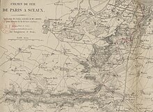
• in solid lines, the route to Sceaux;
• in dashed lines, the branches planned towards Orsay, on one hand, and towards Longjumeau, on the other.


