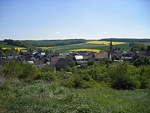
Limbach, Bad Kreuznach
Clockwise from the north, Limbach's neighbours are the municipalities of Merxheim, Kirschroth, Hundsbach, Schweinschied, Hoppstädten, Otzweiler, Becherbach bei Kirn and Heimweiler, all of which but for Hoppstädten, which lies in the neighbouring Kusel district, likewise lie within the Bad Kreuznach district.
Together with Becherbach and Schmidthachenbach, Limbach was one of the biggest places in the Amt of Naumburg, which in the 18th century fell under the lordship of the Margraves of Baden.
After the Napoleonic French had been driven out, Becherbach once again became the mayoral seat for these municipalities, which now became part of the Oberamt of Meisenheim in Hesse-Homburg.
During this Landgravial time, Evangelical inhabitants built a new Gothic Revival church in the years 1858 to 1860 to plans laid out by Meisenheim architect Krausch.
[1] The German blazon reads: In geteiltem Schild oben in Gold ein schwarzer Pflug, unten blau-gold geschacht.
After consent by the state archive, the Ministry of the Interior in Mainz granted approval for Limbach to bear its own arms on 12 May 1965.
[8] The following are listed buildings or sites in Rhineland-Palatinate’s Directory of Cultural Monuments:[9] South of the village, at the junction where Kreisstraße 71 ends at Landesstraße 182, stands a monument dating from 1913 to the memory of the “Freeing of the Rhineland from the 12-Year Enemy Occupation”, a reference to Blücher's success in driving the Napoleonic French out of the region in 1814, 99 years earlier.