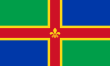
Lincolnshire
The north of the county begins from where the Isle of Axholme is located near the meeting points of the rivers Ouse and Trent near to the Humber.
The rest of the sea boundary runs from Fosdyke to the east of Sutton Bridge, where the current land boundary with Norfolk is located in a narrow area of reclaimed farmland just to the east of the River Nene but until as recently as the early 19th century there was no land border between Lincolnshire and Norfolk as it was separated from each other by the "Cross Keys Wash" a former area of estuary and marshland where the River Nene used to flow out into the Wash and could only be crossed at low tide by a causeway or ferry and was the natural boundary between the two counties.
The causeway known at the time as the "Wash Way" was renowned as being particularly treacherous and the safer route was to go into Norfolk from Lincolnshire via the Cambridgeshire town of Wisbech and this element remains to the present day as the Cross Keys Bridge at Sutton Bridge provides the only direct access point to Norfolk from Lincolnshire over the River Nene some nine miles north of Wisbech.
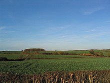
Although the Lincolnshire countryside is intensively farmed, there are many biodiverse wetland areas[citation needed], as well as rare limewood forests.
[34][35] Species which have recently returned to Lincolnshire after extirpation include little egret, Eurasian spoonbill, European otter and red kite.
[36][37] The Local Government Act 1888 established county councils for each of the parts of Lincolnshire – Lindsey, Holland and Kesteven – and came into effect on 1 April 1889.
[citation needed] Lincolnshire has long been a primarily agricultural area, and it continues to grow large amounts of wheat, barley, sugar beet, and oilseed rape.
In south Lincolnshire, where the soil is particularly rich in nutrients, some of the most common crops include potatoes, cabbages, cauliflowers, and onions.
[citation needed] Today, immigrant workers, mainly from new member states of the European Union in Central and Eastern Europe, form a large component of the seasonal agricultural workforce, particularly in the south of the county.
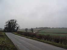
[56] Being on the economic periphery of England, Lincolnshire's transport links are poorly developed compared with many other parts of the United Kingdom.
A daily through train service operated between Cleethorpes and London King's Cross via Grimsby, Market Rasen and Lincoln Central until the late 1980s.
However, the East Coast Main Line passes through the western edge of the county and one can catch direct trains to London from Grantham.
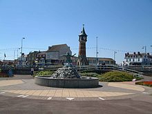
The county has some of the best-known seaside resorts in the United Kingdom, which are a major attraction to visitors from across England, especially the East Midlands and parts of Yorkshire.
There are three main coastal resorts in Lincolnshire and several smaller village resorts: Nature is an attraction for many tourists: the south-east of the county is mainly fenland that attracts many species of birds, as do the national nature reserves at Gibraltar Point, Saltfleetby-Theddlethorpe and Donna Nook, which also contains a large grey seal colony which is popular with visitors.
[63] While Lincolnshire maintains a rural setting, certain parts of the county form urban areas around its larger settlements or growing centres.
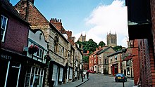
[64] The second largest urban area is Lincoln which incorporates the town of North Hykeham and villages of Bracebridge Heath and Waddington.
[66] In common with most other Northern and Midlands dialects in England, "flat" a is preferred, i.e. /bæθ/ over /bɑːθ/, and also traditionally in words like 'water', pronounced /ˈwætər/ watter (though such a pronunciation is rarely heard nowadays).
The Australian composer Percy Grainger made what are thought to be the first recordings of British Folksongs between 1906 and 1908 in Lincolnshire using a wax Phonograph Cylinder.
[72][73] They included songs sung by Joseph Taylor of Saxby-All-Saints who became the first folk singer to be commercially recorded and whose rendition of Brigg Fair inspired classical works by Grainger and Frederick Delius.
[88] It is held on the Wednesday and Thursday of the last whole week of June at its showground at Grange de Lings, a few miles north of Lincoln on the A15.
[92] Bidding takes place while two boys race toward the Queen's Bridge in Eastgate, the end of which dash is equivalent to the falling of the gavel.
Roger Tuby brings a small funfair to Bourne and then to Spalding in Spring and returns in Autumn at the end of the season.
Throughout the summer the Stamford Shakespeare Company[94] presents the Bard's plays in the open-air theatre at Tolethorpe Hall, which is actually in Rutland.
[100][101] In 2006 it was replaced as the brand of Lincolnshire County Council by the stylised version seen on the header here [1] which has lost even the unique pose of the carving.
The county is home to one daily newspaper, the Grimsby Telegraph which as the name suggests, is published in the town and whose circulation area ostensibly covers North East Lincolnshire, although it reaches as far south as Louth and Alford and as west as Brigg.
One of these, the Stamford Mercury, claims to be Britain's oldest newspaper, although it is now a typical local weekly and no longer covers stories from the whole East Midlands as the archived copies did.
South-west Lincolnshire receives BBC East Midlands and ITV Central which are broadcast from the Waltham transmitting station.
Many villages just west of the Lincoln Cliff cannot get a signal from Belmont due to shadowing and instead get their TV from Emley Moor transmitting station near Huddersfield.
The community radio stations in the county are Endeavour FM in Boston; TMCR 95.3 covering Epworth and Isle of Axholme; and LCR 103.6 in Lincoln.
[106] Since the end of the Second World War most of these airfields or stations were decommissioned, but the RAF retains a significant footprint in Lincolnshire for the air defence of the United Kingdom and aircrew training.