Linguistic boundary of Brittany
The farthest eastern extension of the Breton language was in the ninth century, when the linguistic border was located near Nantes and Rennes.
[1] Place-names are one form of evidence for the linguistic boundary during the Early Middle Ages, suggesting that it was much farther to the east than it is now, near Nantes and Rennes.
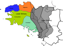
[4] Under the ancien régime, the boundary between the two was generally in line with the province's division into nine bishoprics, with those of Rennes, Dol, Nantes, St Malo and St Brieuc considered to form Upper Brittany, while Tréguier, Vannes, Quimper and Saint-Pol-de-Léon formed Lower Brittany.
[5] In 1588, the historian Bertrand d'Argentré defined the boundary as running from the outskirts of Binic southwards to Guérande, leaving the towns of Loudéac, Josselin, and Malestroit in Upper Brittany.
In 1886, Paul Sébillot noted that the boundary was deeper into what had been Breton territory, the line then running from Plouha on the north coast to Batz-sur-Mer in the south, on the Bay of Biscay.