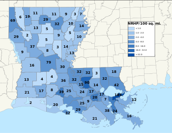
National Register of Historic Places listings in Louisiana
The locations of National Register properties and districts (at least for all showing latitude and longitude coordinates below), may be seen in a map by clicking on "Map of all coordinates".
These counts are based on entries in the National Register Information Database as of April 24, 2008[2] and new weekly listings posted since then on the National Register of Historic Places web site.
[3] There are frequent additions to the listings and occasional delistings and the counts here are approximate and not official.
New entries are added to the official Register on a weekly basis.
[4] Also, the counts in this table exclude boundary increase and decrease listings which only modify the area covered by an existing property or district, although carrying a separate National Register reference number.