List of extreme weather records in Pakistan
Temperatures can range from as high as those in the Sahara Desert, to as low as those in Alaska, making it one of the most climatically diverse countries in the world.
Often, the place most affected by these cold waves is the glacial parts of Gilgit Baltistan, where, in winter, the average temperature remains below -20 °C.
Cities that are near the foothills of the Himalayas, including Islamabad, Peshawar, and Lahore, can record temperatures that are below freezing.
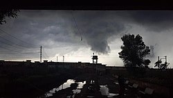
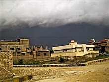
The Monsoon season occurs from July to September and brings a heavy downpour across the country, except in western Balochistan.
Western disturbances occur from October to May and bring rainfall across the country, with some heavy downpour in northern Pakistan.
A low pressure area had developed over the Bay of Bengal, which became a depression, before it hit northern Sindh on 18 August.
The depression became stationary over the northern areas of the province, and caused unprecedented, record-breaking rainfall in places such as Larkana, Naushahro Feroze, Kambar Shahdadkot, Khairpur, Jacobabad, Dadu, Nawabshah, Shikarpur until 22 August.
This occurred when a very low air pressure system (29") was formed over Kashmir; this then moved eastward into Northern Pakistan.
As the last two days of the spell were extremely wet, the River Chenab, Jhelum, Ravi, Sutlej and Indus burst their banks.
[35] After severe drought conditions, which occurred in Sindh during the months of July and August, 2012, an intense low-pressure area developed in the Bay of Bengal.
It produced record breaking, widespread, torrential rainfall, and caused floodig in the district of Badin.
The four spells of monsoon rainfall produced even more devastating torrential rains in the already affected areas of Sindh.
Rainfall of exceeding 200 millimetres (7.9 in) that was recorded in the heaviest monsoon spell, in different areas of Sindh province, during the months of August and September, 2011.
[58][59][60] Unprecedented heavy monsoon rains began, in the last week of July 2010, in the Khyber Pakhtunkhwa, Punjab, Gilgit-Baltistan and Azad Kashmir regions of Pakistan, which caused floods in Balochistan and Sindh.
[61] The floods that were caused by these monsoon rains, and were forecast to continue into early August, were described as the worst in the last 80 years.
[62] The Pakistan Meteorological Department said that over 200 millimetres (7.9 in) of rain fell over a 24-hour period, in a number of places in Khyber Pakhtunkhwa and Punjab, and that more was expected.
[41] Other record-breaking rains were recorded in Risalpur, Cherat, Saidu Sharif, Mianwali, and Kohat regions of Khyber Pakhtunkhwa.
Heavy rainfall exceeding 200 millimetres (7.9 in) that was recorded during the four-day wet spell of July 27 to 30, 2010, in the provinces of Khyber Pakhtunkhwa and Punjab.
Khyber Pakhtunkhwa and North eastern Punjab were badly affected during the monsoon rains, when dams, rivers and lakes overflowed.
[73][74] This flood is considered the worst in Pakistan's history, as it affeced people of all four provinces, including Gilgit Baltistan and Azad Kashmir.
[75] The climate in Pakistan is very unpredictable and extreme, due to its geographical location, and the geography of the country itself, which includes both tropical plains and the world's highest peaks.
[77] Sindh is a fertile region, and is often called the "breadbasket" of the country; the damage and toll of the floods on the local agrarian economy is said to be extensive.