List of hundreds of England
Most of the counties of England were divided into hundreds or wapentakes from the late Anglo-Saxon period and these were, with a few exceptions, effectively abandoned as administrative divisions in the 19th century.
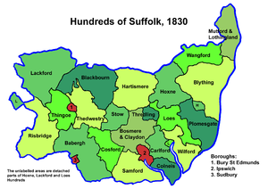
Each hundred had a separate council that met each month to rule on local judicial and taxation matters.
In the Domesday Survey of 1086 are mentioned the wapentakes of Scarvedale, Hamestan, Morlestan, Walecross, and Apultre, and a district called Peche-fers.
From GENUKI Genuki: DERBYSHIRE, England – History and Description, 1868, Derbyshire (based on the 1868 Gazette): In 1850 there were thirty-two hundreds in Devon according to White's History, Gazetteer, and Directory of Devonshire[19] County Durham was divided into wards, analogous to hundreds.
The Domesday Survey mentions 44 hundreds in Hampshire,[23] recorded as HanteScire and abbreviated as Hante.
[26] From Domesday (1086): From The National Gazetteer of Britain and Ireland (1868) Genuki: Miscellaneous Places, Herefordshire, Herefordshire (Danais & Tring added as per History of Hertfordshire)[48] From Kent Genealogy Kent Genealogy England.
In many regions of England as well as Kent, an entire parish would be within one hundred, yet especially along rivers and estuaries which had previously seen invasion, the Kentish hundreds were smaller in area and "shared" parishes to institutionalize resiliency and collective responsibility for defence and justice.
IV were invoked to re-examine the whole structure of Lathes and their divisions in providing for the administration of justice.
The Lower Division of the Lathe of Scray, which formed the southernmost part of the Lathe, became part of West Kent, and consisted of the following Hundreds: Leicestershire was originally divided into four wapentakes, but these were usually later described as hundreds.
From map on Lincolnshire County Council website:[51] [56] In 1086, there were 39 hundreds in the county:[57] Alboldstow, Alwardsley, Barcheston, Beltisloe, Bloxham, Bumbelowe, Cleyley, Coleshill, Collingtree, Corby, Cuttlestone, Fawsley (Foxley), Gravesend (later absorbed into Fawsley Hundred),[58] Guilsborough, Hamfordshoe, Higham, Hunesberi, Huxloe, Kirtlington, Mawsley, Navisford, Navisland, Ness, Nobottle, Offlow, Orlingbury, Polebrook, Rothwell, Spelhoe, Stoke (By the time of the 'Nomina Villarum' a survey carried out in the first half of the 12th century, the Stoke Hundred had been absorbed into the Corby Hundred),[59] Stotfold, Sutton, Towcester, Upton, Warden, Willybrook, Witchley, Wootton and Wymersley.
Following the Harrying of the North and subsequent incursions from Scotland, the high sheriff of Northumberland was granted extraordinary powers.
[91] Medieval sources talk of a group of people who were separate to that of the South Saxons they were known as the Haestingas.
[92] It encompassed the easternmost part of Sussex, with the county of Kent to its east and the Rape of Pevensey to its west.
Hundreds in 1835 were: The ancient hundreds in 1086 at the time of the Domesday survey were:[97] Ash, Came,[98] Celfledetorn, Clent, Cresslow, Cutestornes, Doddingtree, Dudstone, Fernecumbe, Fishborough, Greston, Ossulstone, Oswaldslow, Pershore, Plegelgete, Seisdon, Tewkesbury, Tibblestone, Wolfhay.
The hundreds that continued their courts until disuse include: Yorkshire has three Ridings,[104] East, North and West.