List of islands in the Detroit River
Belle Isle sits at an elevation of 574 feet (175 m) above sea level, and the island has also gone by several historic names.
The island is a very popular tourist destination that contains a number of historic structures and events.
[4] The island, which is within Grosse Ile Township, is uninhabited and serves primarily as a nesting location for migrating birds.
[9] The island is part of Lake Erie Metropark and contains the park's boat launch.
The island is located on the western shores of the Trenton Channel and sits at an elevation of 591 feet (180 m) above sea level.
[15] Once connected to the mainland, it was set off by the construction of a canal by landowner Giles Bryan Slocum in the mid-nineteenth century.
Today, the island encompasses the 162-acre (65.6 ha) Elizabeth Park on the northern end and the Trenton Channel Power Plant on the south.
Originally, the island was much smaller, but it served as a disposal facility for millions of cubic yards of sediments that were dredged from the expanding of the River Rouge.
The island sits at an elevation of 574 feet (175 m) above sea level in the southern portion of the river.
Grosse Ile contains numerous historic structures and is primarily residential with little economic development.
[22][23] The 40-acre (16.2 ha) Gibraltar Bay Unit of the Detroit River International Wildlife Refuge is located in the southeast portion of the island.
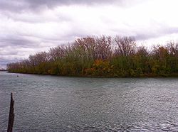
[6][25] The island is uninhabited and inaccessible, and it is noted as the last undeveloped shoreline on the American side of the Detroit River.
It is connected to the mainland by the Horse Island Drive Bridge, which is 46 feet (14 m) long and was constructed in 1925.
The island is connected to the mainland at the north end by the historic Gibraltar Road–Waterway Canal Bridge, which is 52 feet (16 m) long and was constructed in 1932.
The island was once 30 acres (12.1 ha) in size and contained the historic Mama Juda Lighthouse, which was first built in 1849.
[31] Although the island is gone, it is still listed on some online maps and may surface during times of low water levels.
The island was donated by the National Steel Corporation and is the northernmost unit included in the Detroit River International Wildlife Refuge.
It is separated from Grosse Ile by a narrow canal that is used for docking boats at the Ford Yacht Club.
[38] The island's unusual shape and stony composition are the result of millions of cubic yards of sediment that were dredged out of the middle of the Detroit River to provide a deep shipping lane.
The island has also been reinforced and surrounded by numerous breakwater structures to protect the artificial wetlands.
The island has undergone this restoration project with funding from the National Oceanic and Atmospheric Administration.
[41] Beginning in the 1880s, Sugar Island became a popular resort location, and it eventually contained an amusement park and other entertainment venues.
Swan Island is located southwest of Grosse Ile, and it is separated by a narrow canal and connected by a single bridge.
In 1902, the island became site of several steel mills during the age of rapid industrial development along the Detroit River.
The small bay is protected by the island from the river's current and pollution, thus creating an unusually calm and clear shelter.
While the island itself is off limits since it serves as a nature preserve, the bay is a popular destination for boaters and fishermen.
[6] Fighting Island is administered by the town of LaSalle, but it is privately owned by the German-based BASF, which has a facility across the river in Wyandotte.
The island originally had a small indigenous population before it was purchased by the Michigan Alkali Company in 1918.
In 1989, it was reported that 80% of the island was covered in highly acidic brine waste, which also caused dust clouds to travel to nearby communities.
[56][57] The island was originally privately owned and used as a lavish summer residence for Hiram Walker and later others.