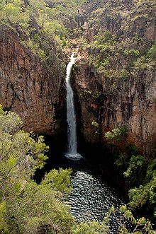
Litchfield National Park
Litchfield National Park, covering approximately 1500 km2, is near the township of Batchelor, 100 km south-west of Darwin, in the Northern Territory of Australia.
This was the first European expedition to visit the Top End of Australia by land and it was their aim to explore as widely as possible and establish a settlement at Escape Cliffs, on the mouth of the Adelaide River.
Previous attempts at settlement of Australia's northern coast at Fort Dundas, Raffles Bay and Port Essington had already failed.
There are fine plains here, splendidly grassed and watered; small belts of stunted gum, vaquois, fan palm, and honeysuckle.
By 1941 miners began following the tin-bearing seams into the hills using picks and shovels, and loading the ore into wagons to be pushed or pulled back to the mines' entrances.
In 1924 a small homestead was built by the Sargent family on their leased land in the lowlands near Tolmer Falls where there was reliable water and reasonable grazing for their cattle.
Their farm proved successful and in 1928 they built Blyth Homestead as an outstation a little further south, so their cattle could take advantage of the good grazing among the paperbarks in this area.
Typical of other structures of that time, the homestead is supported with cypress pine tied together with heavy wire and covered with corrugated iron.
The family was able to farm their own vegetable and fruit crops, and held up to 13,500 head of cattle, due to the permanent water nearby.
Production from the open cut area started in 1953 and proved to be one of the largest economic influences in the development of the Top End, with sales to the United Kingdom for their atomic weapons program.
The invasive species Andropogon gayanus, better known as gamba grass is a significant threat to the park’s biodiversity due to the frequent, high intensity, late dry season wildfires it exacerbates.
[5][6][7] Researchers estimate that this will increase to as much as 30% by 2033, a major threat to the park's future due to the extreme fire risk, the severity of which can destroy locals species.
[9] Common wildlife species include the antilopine kangaroo, agile wallaby, sugar glider, northern brushtail possum, fawn antechinus, black and little red flying foxes and the dingo.
The yellow oriole, figbird, Pacific koel, spangled drongo, dollarbird and the rainbow bee-eater inhabit the sheltered areas close to waterfalls.
A species of marsupial mouse (the northern dibbler), the rufous-tailed bush-hen, a frog (the pealing chirper) and the primitive archerfish, occur in the Wangi Falls area.
The remains consist of the homestead building itself which is a single room, cypress pine and corrugated iron structure encircled by verandahs; a flagstone floor; a scatter of corrugated iron, sandstone blocks and other metal objects; and a set of stockyards constructed using bush timber poles and barbed wire The homestead was established in 1928 to function as an outstation on Stapleton Station, then owned by Harry Sargent and his family.
It was constructed using bush timber (cypress pine) and iron in the form of a large central room that could be closed up with verandahs around the edges.
Their income was supplemented by alluvial and reef tin mining to the east of the homestead, the products of which had to be carted by buckboard along a self-made track over the Finiss River.
The simple bush architecture of the homestead and the opportunistic nature of the mine workings illustrate the harsh conditions under which the Sargent family lived.
After a moderate level, 3.5 km return walk through an open valley, visitors can enjoy the usually un-crowded plunge pool beneath Tjaynera Falls.
Interpretive signs explain the methods used to extract the tin and to help appreciate the hardship endured by miners as they struggled to make a living in intolerable conditions.
The Tabletop Track, within Litchfield National Park, is a 39 kilometre bushwalk along trickling creeklines, cascading waterfalls, crystal clear pools and undisturbed pockets of tropical monsoon rainforest.
Forming part of the Tabletop Track in Litchfield National Park, this 22 kilometre walk will take you to Greenant Creek, through pockets of cool monsoon rainforest inhabited by a variety of birdlife.
This eight and a half kilometre walk, which forms part of the Tabletop Track in Litchfield National Park, takes you from Greenant Creek through to Wangi Falls.
This final trek of the Tabletop Track in Litchfield National Park, will take you from Walker Creek to Florence Falls.
Spot local wildlife including wallabies and possums, or listen to some of the curious bird calls from the variety of birdlife that also inhabit this forest area.