Liv Glacier
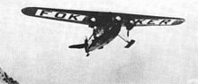
[2] According to Sailing Directions for Antarctica (1960), "The Liv Glacier (85° S. 168° W.) reaches the Ross Ice Shelf on the western side of the Duncan Mountains.
It was originally referred to as the "Hump" by Rear Admiral Richard E. Byrd and is the pass over which he made his historic South Pole flight of 1929.
The southernmost of three large nunataks in upper Liv Glacier, about 5 nautical miles (9.3 km; 5.8 mi) north-north-east of Barnum Peak.
The central of three nunataks in mid-stream of the upper Liv Glacier, standing about 4 nautical miles (7.4 km; 4.6 mi) southeast of Mount Wells, in the Queen Maud Mountains.
Named by the Southern Party of the NZGSAE (1961-62) for Harold June, aviator and engineer on the South Pole flight of R. Admiral Richard E. Byrd in 1929.
The northernmost of three large nunataks in the upper Liv Glacier, standing 4 nautical miles (7.4 km; 4.6 mi) east of Mount Wells.
Cornelius B. de LaVergne, Deputy Commander of Antarctic Support Activity at McMurdo Station during USN OpdFrz 1961.
Discovered and photographed by R. Admiral Byrd on the South Pole Flight in November 1929 and named for Joe DeGanahl, navigator and dog driver and member of the Supporting Party, ByrdAE, 1928-30.