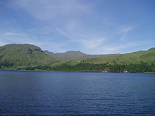
Loch Katrine
It is a popular scenic attraction for tourists and day-visitors from Glasgow and nearby towns; fly and boat fishing for trout are permitted on the loch from spring to autumn.
It also serves as a reservoir for the water supply of the Glasgow conurbation, some 30 miles (48 km) south, being connected by two aqueducts constructed in 1859.
It is the fictional setting of Sir Walter Scott's poem The Lady of the Lake and of the subsequent opera by Gioachino Rossini, La donna del lago.
[2] The name Katrine has also been hypothesized to represent cateran, from the Gaelic ceathairne, a collective word meaning cattle thief[3] or possibly peasantry.
The deepest part is in the centre of the loch, a long narrow depression, with depths exceeding 400 feet (120 m), extending for over 4 miles (6.4 km) from opposite Coilachra to opposite Huinn Dubh-aird, with a maximum width of over one-quarter of a mile (0.40 km); this 400-feet depression has an area of about 515 acres (208 ha), or 17% of the entire superficial area of the loch.
[5] Near the upper end of the loch a rocky barrier crosses the lake from Portnellan by the Black Island to Budha Maoil Mhir an-t Salainn.
Above it there is another basin over half a mile in length, the greatest depth of which is 128 feet (39 m), immediately in front of the rocky ridge just referred to.
Westwards the lake shallows, and at its head it has been silted up for a distance of half a mile by alluvium laid down by Glengyle Water.
[5] Below Brenachoil Lodge the soundings show an uneven floor, due probably to ridges of rock rather than to morainic deposits, judged from the geological features on both sides of the lake.
The deepest sounding occurs in the front of the great rocky barrier in the lower part of the lake, in accordance with a theory of glacial erosion.
[11] The treatment works in Milngavie are almost 100 metres (330 ft)[12] above sea level: sufficient to provide adequate water pressure to the majority of the town without the need for pumping.
It was coal-fired until 2007, when it was converted to use bio-diesel fuel, and continues to provide local tourist transport between Trossachs Pier and Stronachlachar during the summer.