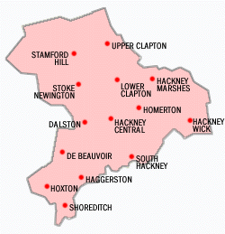
London Borough of Hackney
The historical and administrative heart of Hackney is Mare Street, which lies 5 miles (8 km) north-east of Charing Cross.
Hackney is bounded by Islington to the west, Haringey to the north, Waltham Forest to the north-east, Newham to the east, Tower Hamlets to the south-east and the City of London to the south-west.
This continuity of this natural boundary from pre-Roman period may be a result of the differing Saxon groups taking control of pre-defined territories.
After both areas were brought under the control of Alfred the Great, the river became the boundary between the historic counties of Middlesex (Hackney) and Essex (modern Newham, Waltham Forest and Redbridge).
Henry VIII's Palace was by Lea Bridge roundabout, where BSix Sixth Form College stands today.
[4] Sutton House, on Homerton High Street, is the oldest surviving dwelling in Hackney,[5] originally built in 1535 as Bryck Place for Sir Ralph Sadleir, a diplomat.
Construction of the railway in the 1850s ended Hackney's rural reputation by connecting it to other parts of the city and stimulating development.
In 1727 Daniel Defoe said of the villages of Hackney All these, except the Wyck-house, are within a few years so encreas'd in buildings, and so fully inhabited, that there is no comparison to be made between their present and past state: Every separate hamlet is encreas'd, and some of them more than treble as big as formerly; Indeed as this whole town is included in the bills of mortality, tho' no where joining to London, it is in some respects to be call'd a part of it.This town is so remarkable for the retreat of wealthy citizens, that there is at this time near a hundred coaches kept in it; tho' I will not join with a certain satyrical author, who said of Hackney, that there were more coaches than Christians in it.
Many grand houses stood in Stoke Newington and Stamford Hill; the latter neighbourhood became a center of Hackney's many Orthodox Jewish residents from the 1930s.
[14][15][16] Following extensive post-war development and immigration since the late 20th century, population pressure has increased and the area's many Georgian and Victorian terraces are being gentrified, warehouses are being converted to housing, and new flats are being built.
[33] The area of the modern borough broadly corresponds to the three ancient parishes of Hackney, Shoreditch and Stoke Newington, which had all historically been part of the Ossulstone hundred of the county of Middlesex.
From 1856 the area was governed by the Metropolitan Board of Works, which was established to provide services across the metropolis of London.
[37] There were some rationalisations to boundaries, notably that Shoreditch absorbed part of the tiny Liberty of Norton Folgate (with the rest going to neighbouring Stepney).
These proposals were rejected due to the experience of "intolerable and interminable feuds" between the districts when they were previously "forced together".
The First Lord of the Treasury, Arthur Balfour recognised that there was "great ill-feeling and mutual ill-will... between the inhabitants of the two districts".
A speaker fulfils the civic and ceremonial duties previously undertaken by the (non-political) mayor prior to 2002.
The borough comprises two parliamentary constituencies: Hackney North and Stoke Newington (represented by Diane Abbott MP) and Hackney South and Shoreditch (represented by Meg Hillier MP); both are Privy Counsellors and Labour Party Members of Parliament.
Despite this, many areas have only a weakly or partially understood extent and it is not unusual for perceptions of place to overlap or change over time.
The London Borough of Hackney covers an area of 19.06 km2 (7.36 sq mi), rising westward from the Lea to reach 30 m (98 ft) above sea level at Clapton Common and Stamford Hill.
The area around Victoria Park, in the south of the borough lies about 15 metres (49 feet) above sea level.
After the Norman Conquest the area became part of the Forest of Middlesex, which covered much of the county, but this gives rise to misunderstanding, as in this context "Forest" is a legal term referring to royal hunting rights and had a weak correlation with woodland cover, especially in the early post-Conquest Period.
[43] Much of Hackney retains an inner-city character, but in such places as Dalston large housing estates have been joined by newly developed gated communities.
In South Hackney, near Victoria Park, terraced Georgian, Victorian and Edwardian housing still survives.
The Lea and Hackney Marshes are underlain by alluvium soils; and the higher ground between Homerton and Stamford Hill is formed on a widening bed of London Clay.
Brickearth deposits are within tongues of clay extending beneath Clapton Common, Stamford Hill and Stoke Newington High Street.
[43] This data was taken between 1971 and 2000 at the nearest national weather station in Greenwich; around 7 miles (11.3 km) south of Hackney Town Hall: In 1801, the civil parishes that form the modern borough had a total population of 14,609.
[51][52] Turkish and Kurdish communities are located in all parts of the borough, though there is a greater concentration in north and central Hackney.
[71] In 2002, the borough entered into a 10-year contract with the Learning Trust, an independent collaborative body that organises education for Hackney's 27,000 pupils in over 70 schools, nurseries and play centres.
North London Line Travelling west to east — Dalston Kingsland, Hackney Central, Homerton and Hackney Wick East London Line Travelling north to south — Dalston Junction, Haggerston, Hoxton and Shoreditch High Street Lea Valley Lines Travelling south to north – London Fields, Hackney Downs, Rectory Road, Stoke Newington and Stamford Hill.
In March 2011, the main forms of transport that residents used to travel to work were: bus, minibus or coach, 16.9% of all residents aged 16–74; underground, metro, light rail, tram, 9.2%; bicycle, 9.2%; on foot, 7.5%; driving a car or van, 7.1%; train, 4.6%; work mainly at or from home, 3.5%.