Long Bay, New Zealand
Long Bay (Māori: Oneroa)[4] is one of the northernmost suburbs of the North Shore, part of the contiguous Auckland metropolitan area located in New Zealand.
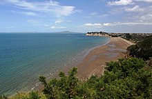
[18][19] Smaller beaches to the north, such as Pohutukawa Bay, accessible except at high tide, are among Auckland's most popular naturist spots;[9][20] The headland at the northeast of the suburb is called Piripiri Point.
[21] The land at Long Bay is primarily made up of Waitemata Group sandstone, which formed during the Miocene approximately 16 to 22 million years ago on the seafloor.
[5] Prior to human settlement, inland Long Bay was primarily a northern broadleaf podocarp forest, dominated by tōtara, mataī, miro, kauri and kahikatea trees.
[23][7] The North Shore was settled by Tāmaki Māori, including people descended from the Tainui migratory canoe and ancestors of figures such as Taikehu and Peretū.
[27][28] A major conflict between Maki and Ngā Oho occurred in southern Long Bay called Te Whakarewatoto,[7] which became a name his Ngāti Manuhiri descendants used for the area.
[26][13] By the 18th century, the Marutūāhu iwi Ngāti Paoa had expanded their influence to include the islands of the Hauraki Gulf and the North Shore.
[32] The earliest contact with Europeans began in the late 18th century, which caused many Tāmaki Māori to die of rewharewha, respiratory diseases.
[9] The first Europeans to visit the area were in the 1830s, when timber merchants and kauri gum diggers harvested resources from Long Bay.
[35][36] The first European settlers arrived in the 1850s,[12] including Alexander Pannil and Joshua Alias, who worked to clear the bush for farming.
[6] In 1860, Captain Charles Cholmondeley-Smith and his family leased land at Long Bay for a sheep farm, but left after three years as the venture was unsuccessful.
[6] In 1862, the Vaughan family purchased 600 acres of farmland at Long Bay, where they ran a sheep and cattle farm for 100 years.
[13] In 1929 Tom Vaughan, opened a campground for holidaymakers at the southern end of the beach, near the Awaruku Creek.
[38] During the Second World War, a gun emplacement was built on the coast north of the park in case to defend against invasion by Japanese forces.
[41] Areas of farmland above Long Bay Regional Park were protected from development by an Environment Court ruling in July 2008.
[42][43] Due to changes in the Auckland Council's Unitary Plan, major housing developments were constructed at Long Bay in the late 2010s.
[47][48] On 1 August 1974, the Waitemata County was dissolved,[49] and Long Bay became a rural area incorporated into Takapuna City.