Long Island Sound link
Feasibility studies for bridges and tunnels have been conducted for numerous entry points, as listed in the chart below.
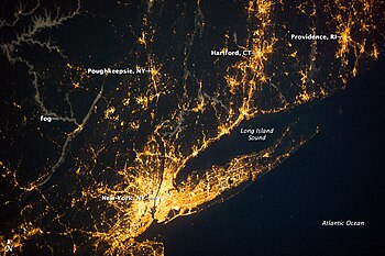
People who wish to drive from Long Island to New York state's mainland or to any part of New England have no better option than to cross the Throgs Neck Bridge or the Bronx–Whitestone Bridge, which are located on the northwestern corner of Long Island connecting the New York City boroughs of Queens and the Bronx.
Opponents of such a crossing argue that the cost of such a bridge or tunnel would be large and it would be likely to have adverse environmental impacts.
If built, a span across the widest portion of the Sound between New Haven and Shoreham would be approximately 22 to 25 miles (35 to 40 km) in length, possibly making it one of the longest bridges in the world.
The proposed bridge was to cost $150 million (1966 USD) and had the support of New York Governor Nelson Rockefeller and many officials on Long Island.
The next year, there was a gubernatorial election for Rockefeller, and with the affected communities up in arms against him, he did not want to be put on the spot while running for re-election as governor.
That same year, new federal laws that dealt with the environment required a new Environmental Impact Statement for the highway, this time for the approaches as well.
[8] With the mainline construction of the Seaford – Oyster Bay Expressway completed, Moses turned his eyes back onto an extension of the freeway and onto a bridge across the Long Island Sound into Westchester County (in the city of Rye).
Based on the Nassau County Department of Public Works Master Plan of 1959, the expressway would follow West Shore Road and Lundlum Avenue through Oyster Bay to Bayville, where it would connect to the new crossing.
[10] In November 1972, Moses, the recently created New York State Department of Transportation, and the MTA submitted the environmental impact statement (EIS) for the bridge.
These minimums reported by the two authorities and Moses were equal to those of the bridges crossing the East River in New York City.
The main span would have a median divider separating the directional lanes, along with a girder box to allow for smooth passing.
The approaches were to have retaining walls, side slopes, and screening which were to help blend in with the area and reduce the number of properties seized.
The second alternative, designated N-2, utilized most of N-1's route except for a cut through Mill Neck and onto a viaduct about 2,000 feet (610 m) long with varying clearances.
The route would then pass to the east of the business district in Bayville and cross over the Mill Neck Creek on a viaduct with a 30 feet (9.1 m) clearance.
Because the bridge will contribute to a healthy economic development of the region, it will have a favorable general effect on property values and therefore on the tax base.
For the first time, highway access will be available for freight movements to and from Long Island without the need to overcome New York City congestion.
Secondary economic benefits also will be realized from expenditures by workers employed on the project, both in the vicinity of the bridge site and elsewhere in the region.
Faced with growing opposition, Governor Rockefeller canceled the plans for the bridge on June 20, 1973, nine years after the first proposal by Moses.
[12] In January 2008, this idea was revived when developer Vincent Polimeni proposed building a privately financed, tolled tunnel between Oyster Bay on Long Island and Rye in Westchester County, featuring two tubes carrying three lanes of traffic each and a third tube for maintenance and emergency access.