Long Wharf (Boston)
It once extended from State Street nearly a half-mile into Boston Harbor; today, the much-shortened wharf (due to land fill on the city end) functions as a dock for passenger ferries and sightseeing boats.
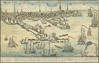
As originally built the wharf extended from the shoreline adjacent to Faneuil Hall and was one-third of a mile long, thrusting considerably farther than other wharves into deep water and thus allowing larger ships to tie up and unload directly to new warehouses and stores.
[5] Among several similar structures, a grand granite warehouse known as the Custom House Block was built in 1848 atop the wharf; it has survived into the 21st century.
[7] In the late 1860s, as the city's port began to decline in importance as an international shipping destination,[7] Atlantic Avenue was cut through this and other wharves, changing the face of the waterfront.
The wharf and the 19th-century Custom House Block were recognized as a National Historic Landmark in recognition for the role they played in the history of Boston and its importance as a major 19th-century shipping center.
[7] The Big Dig put the Central Artery below ground level, which partially restored the original close relationship between Long Wharf and downtown.
MBTA boat services link the wharf to the Boston Navy Yard in Charlestown, Logan International Airport, Hull, and Quincy.