Longhai, Zhangzhou
[3] Following the revocation of the sea ban (haijin) in the late Ming, Yuegang (within present-day Haicheng in Longhai) became a key port for China's silver trade with Manila in the Spanish Philippines.
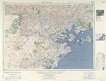
Longhai located along the lower banks of the Jiulong River, with mountainous terrain in its western, southern, and northern portions, and the Xiamen Bay to its east.
[6] The city's highest point is Mount Dajian (大尖山) in Chengxi [zh], which reaches 953.6 metres (3,129 ft) in elevation.
[6] The city's lowest point is Jiujiejiao (九节礁) on Wuyu Island (浯屿岛) in Gangwei, which lies 47 metres (154 ft) below sea level.
[6] Major minerals mined in Longhai include granite, tuff, peat, feldspar, and kaolin.
[citation needed] Railway development plans also include the construction of a 45-km-long branch line from Zhangzhou Railway Station eastward, across most of Longhai City to terminate at the Zhangzhou China Merchant's Group Development Zone [zh] in Gangwei on the southwestern shore of Xiamen Harbor, opposite Xiamen Island (24°24′00″N 118°03′00″E / 24.40000°N 118.05000°E / 24.40000; 118.05000).
[citation needed] The branch will be known as Gangwei Railway (港尾铁路), and will support trains running at speeds up to 120 km/h.