Los Amates
[5] The area was largely abandoned during the Spanish Colony of Guatemala, and the first European visitor to publish an account of Los Amates was English architect and artist Frederick Catherwood, who reached the Quiriguá ruins in 1840, during the turbulent times of president general Rafael Carrera.
[6] The previous landowner, by the surname of Payés, had related the existence of the ruins to his sons and to Carlos Meiney, a Jamaican Englishman resident in Guatemala.
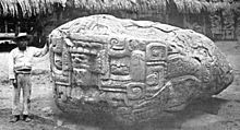
Explorer and archaeologist Alfred Maudslay visited Quiriguá for three days in 1881; they were the first pre-Columbian ruins that he saw and they were sufficiently impressive to inspire him to take up a permanent interest in Central American archaeology.
[9] In 1910, the United Fruit Company bought Quiriguá, Los Amates and all the land for a great distance around for banana production; they set aside 75 acres (30 ha) around the ceremonial centre as an archaeological park, leaving an island of jungle among the plantations.
In early 1920, after the Unionist party deposed Manuel Estrada Cabrera, the United Fruit Company -which had received considerable concessions from the Guatemalan president in the past two decades in Izabal- was suddenly confronted with a large strike and did not have the help from the government to repress it due to the fighting taking place in Guatemala City.
The strike grew stronger and upon the resistance of the Unionists to help it, UFCO supported a coup d'état led by general José María Orellana in 1921, who swiftly repressed the union members and gave tranquility to the United Fruit Company operations in Izabal.
[15] In 1964, the National Institute for Agrarian Transformation (INTA) defined the geography of the FTN as the northern part of the departments of Huehuetenango, Quiché, Alta Verapaz and Izabal and that same year priests of the Maryknoll order and the Order of the Sacred Heart began the first process of colonization, along with INTA, carrying settlers from Huehuetenango to the Ixcán sector in Quiché.
[16] The Northern Transversal Strip was officially created during the government of General Carlos Arana Osorio in 1970, by Decree 60-70 in the Congress, for agricultural development.