Louisiade Archipelago
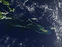
It is located 200 km southeast of New Guinea, stretching over more than 160 kilometres (99 mi) and spread over an ocean area of 26,000 square kilometres (10,000 sq mi) between the Solomon Sea to the north and the Coral Sea to the south.
The aggregate land area of the islands is about 1,871 square kilometres (722 sq mi), with Vanatinai (Tagula) being the largest.
[citation needed] The 1942 Battle of Coral Sea was fought nearby, after Japanese occupation in the same year.
The seat of the Louisiade Rural LLG is Bwagaoia on Misima Island, the population center of the archipelago.
The seat of the Bwanabwana was Samarai from the Louisiade archipelago, but was recently transferred to the mainland of Papua New Guinea to the city of Alotau.