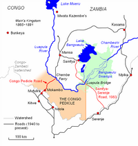
Luapula Province
The province is bordered along the Luapula River, through Lake Mweru and to its north by DR Congo.
Around 80.5 per cent of the population of Luapula is accounted as poor in 2010 census, making it the poorest of all provinces in Zambia.
Major mineral deposits found in the province are manganese, lime, copper and precious metals.
[3] The boundaries of the province between Zambia and DR Congo were disputed for many years, running from an 1894 treaty into the late 1960s.
Laupula has constant migration of labour from DR Congo and also from nearby Copperbelt Province.
During the 1980s, the then President Kenneth Kaunda appointed traditional Chiefs of the region as District Governors or members of the powerful UNIP central committee.
The practice was seen similar to colonial rule when local leaders were drafted to political domain.
[4] Frederick Chiluba, the leader of Movement for Multi-Party Democracy (MMD), who went on to become the President of Zambia in 1991, obtained majority mandate during the 1991 elections.
[5] The province is bordered along the Luapula River, through Lake Mweru and to its north by DR Congo.
The Congo Pedicle is located between the province and the industrial and commercial heartland of the Copperbelt.
Major mineral deposits found in the province are manganese, lime, copper and precious metals.
Sweet potato was the major crop in the province with 11,356 metric tonnes, constituting 7.56 per cent of the national output.
[29] As per the International Monetary Fund (IMF) paper on Poverty Reduction in Zambia published in 2007, there were 360 basic government schools, 18 high schools, one teacher training college and one trade training college as of 2000.
There is a Deputy Permanent Secretary, heads of government departments and civil servants at the provincial level.
[32] The administrative staff of the council is selected based on the Local Government Service Commission from within or outside the district.
The government stipulates 63 different functions for the councils with the majority of them being infrastructure management and local administration.
Councils are mandated to maintain each of their community centres, zoos, local parks, drainage system, playgrounds, cemeteries, caravan sites, libraries, museums and art galleries.
They also work along with specific government departments to help in agriculture, conservation of natural resources, postal service, establishing and maintaining hospitals, schools and colleges.
[35] Lusenga Plain National Park and Bangweulu Wetlands are the major wildlife areas in the province.
The event involves enacting the migration of Luba Lunda and conquest of the valley by the chiefs of the tribe during historic times.