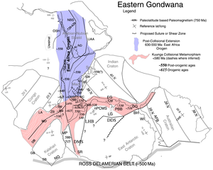
Lufilian Arc
It extends across eastern Angola, the Katanga Province of the southern Democratic Republic of the Congo and the northwest of Zambia.
Extension was replaced by compression as the Kalahari and Congo cratons moved back towards each other at the start of the Pan-African orogeny.
Nappes advancing from the south deposited olistostrome detritus into the Fungurume foreland basin to the north of the arc.
Compression deformed the Katanga supergroup sedimentary rocks into a fold and thrust belt, the Lufilian Arc.
[5] The orogeny lifted and folded Roan strata holding copper and cobalt deposits, which later became exposed through erosion.
[6] The Mwembeshi Shear Zone forms the southern boundary of the Lufilian Arc, separating it from the Zambezi belt.
Above this the Nguba group until recently has been defined as strata that begin with a diamictite layer, probably created by Sturtian glacial action.
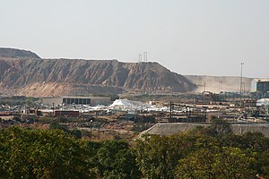
[12] The Lufilian Arc contains the 520 kilometres (320 mi) African copperbelt, which runs in a northwesterly direction from Zambia into the Katanga Province in the Democratic Republic of the Congo (DRC).
Additional advantages are that the mines mostly contain sulphide ores, which are comparatively easy to concentrate and smelt, and that labor costs are low.