M-28 (Michigan highway)
Throughout its course across the Upper Peninsula, M-28 passes through forested woodlands, bog swamps, urbanized areas, and along the Lake Superior shoreline.
After crossing into southwestern Ontonagon County and the Eastern Time Zone, the trunkline highway skirts the northern shore of Lake Gogebic, running concurrently with M-64.
At the eastern junction with US 41 near Covington, M-28 receives the Circle Tour designation again[4] and exits the Ottawa National Forest.
[11][12] The Lakenenland sculpture park is located in Chocolay Township near Shot Point in eastern Marquette County.
This roadside attraction is owned by Tom Lakenen and features fanciful works of art made of scrap iron.
The roadway also features variable-message signs to warn motorists of winter weather-related traffic closures along the lakeshore.
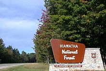
[14] The highway exits the Hiawatha National Forest at the Alger County–Schoolcraft County line along the Seney Stretch.
"[18] The highway is often cited as the "state's most boring route" according to the Michigan Economic Development Corporation (MEDC) and Hunts' Guide.
The most significant changes made to the stretch since its original construction were the addition of passing relief lanes and a full-scale, year-round rest area in 1999.
The Circle Tour departs M-28 to follow M-123 at Newberry, looping north to the Tahquamenon Falls State Park.
From there, M-28 crosses the east and west branches of the Sage River and passes south of Soo Junction, before the Chippewa County border.
The highway leaves the eastern unit of the Hiawatha National Forest between the communities of Raco and Brimley.
[26] The highway meets Interstate 75 (I-75) at exit 386, and the Lake Superior Circle Tour departs M-28 to follow I-75.
[4] A park with a picnic area and a footbridge lies near Tioga Creek in Baraga County east of the US 41 junction.
Three other roadside parks lie east of Harvey in Shelter Bay, on the shores of Deer Lake and west of Newberry.
[4] Formed by July 1, 1919, M-28 began in Wakefield at a junction with then M-12 and ran roughly along the current alignment to end at M-15, 6.5 miles (10.5 km) east of Covington.
M-28 was extended in 1927 along US 41 into Marquette County and east over M-25 through Chatham, Munising, and Newberry, before ending in downtown Sault Ste.
[43] The last significant change to the M-28 routing occurred on March 3, 1989, when the eastern terminus was moved east to M-129.
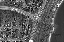
[44] MDOT unveiled plans on March 31, 2009, to rebuild the intersection between Front Street and the eastern end of the Marquette Bypass during 2010.
[45] The previous intersection configuration dated back to the 1960s and had been labeled as "dangerous and [causing] significant traffic delays" by the designers of the replacement.
MDOT decided in favor of a two-lane, 150-foot (46 m) roundabout retaining the right-turn lanes from the previous intersection layout.
Although this section was bypassed by a new alignment of the trunkline in 1924, the bridge remains complete "with corbeled bulkheads and six panels recessed in the concrete spandrel walls.
Today, drivers cannot use the Peshekee River Bridge south of US 41/M-28 in western Marquette County's Michigamme Township.
[55] The next historic bridge listed by MDOT along M-28 is over the Sand River in Onota Township in Alger County.
The bridge over the East Branch of the Tahquamenon River in Chippewa County was built in 1926 as a "formative exercise in what would evolve into a state standard design.
Several proposals have arisen, including creating a "spur" from US 41/M-28 through the east end of Ishpeming to meet CR 480 west of Negaunee.
If jurisdiction is transferred, and M-28 is routed over CR 480 as proposed, M-28 would leave the concurrency with US 41 near Teal Lake in Negaunee, and cross the caving grounds west of downtown to connect to Rail Street.
One would route M-28 back along US 41 from Beaver Grove north of the CR 480 eastern terminus to the existing M-28 in Harvey.
[67] The entire business loop was turned back to local control in a "route swap" between the City of Marquette and MDOT announced in early 2005.
[68] The transfer would increase Marquette's operational and maintenance liability expenses by $26,000 (equivalent to $39,000 in 2023[59]) and place the financial burden of the future replacement of a stop light on the city.