M-6 (Michigan highway)
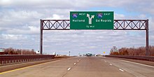
M-6 also provides a connection to U.S. Highway 131 (US 131) in the middle of its corridor while running through several townships on the south side of the Grand Rapids metropolitan area in Western Michigan.
In advance of the opening of the freeway to traffic, the Michigan Department of Transportation (MDOT) allowed the public to walk or bike the South Beltline in an open-house event called the "Southbelt Shuffle".
On either side of the freeway at Byron Center Avenue, there are two hospitals, Metro Health and St. Mary's Southwest, the former located on the very southern edge of the city of Wyoming.
In the eastbound direction, the collector-distributor lane also has access to a ramp for traffic bound for 68th Street, which runs parallel to, and south of, the M-6 freeway.
[3][4][5] East of US 131, M-6 crosses over Division Avenue and enters Gaines Township through a series of sound barrier walls as the freeway ramps merge back into the main lanes.
[6] Near Kalamazoo Avenue, the freeway passes through an area with retail businesses and movie theaters on each side of the interchange; to the northeast is East Kentwood High School.
On the approach to the East Paris Avenue underpass, M-6 curves first to the northeast and then back to the southeast, passing near one of Steelcase's office buildings, the pyramid-shaped Corporate Development Center.
The freeway begins to curve to the northeast as it crosses into Caledonia Township, with an interchange for M-37 (Broadmoor Avenue) and an overpass for 60th Street.
[17] The 1955 planning map for the Grand Rapids area Interstate Highways included a freeway roughly along the M-6 corridor before I-96 and I-196 were shifted north and east to their current locations.
[21] The choice of consultants on the project was controversial; local planners felt that MDOT picked BKI Inc. only because they used a minority-owned subcontractor and not because they would be qualified for the assignment.
[23] The boundaries for the highway corridor were determined by the consultants in April 1982, running between 60th and 84th streets, "dipping like a hammock beneath the cities of Kentwood and Wyoming".
[21] An editorial in The Grand Rapids Press stated that the study did not help advance the project in the area, instead opening the proposed freeway up to new controversies.
In the interim, work was shifted to local and state planners until a new consultant could be retained in an effort to minimize the delays involved.
These local projects were focused on updating the information and maps from BKI's study and refining the scope of the highway's corridor.
[27] Gaines, Cascade, and Caledonia townships and the city of Kentwood circulated a survey amongst their communities' planning commissions and elected boards in 1982.
The survey showed an inconclusive preference for a limited-access highway in what was termed a "gut level reaction" to the proposed roadway.
[28] The South Belt Citizens Committee actively started to oppose the roadway during the fall of 1982, pressing local candidates for political office to take positions on the project.
[29] Future Lieutenant Governor Dick Posthumus, then a member of the Michigan State Senate, called for an end to the studies in 1983;[30] he would later reverse and become one of the project's biggest supporters.
[20] The Michigan State Legislature named the South Beltline around the same time for the Congressman Paul B. Henry, who died in office in 1993, serving in Gerald Ford's old US House seat.
[32] The cost of the construction of new roads like the South Beltline was a campaign issue when Engler ran for re-election against Geoffrey Fieger in 1998.
MDOT gave the South Beltline its numerical designation on the July 1999 edition of the state map, marking M-6 for the first time as a dotted line, to denote it was "under construction".
[20] The legislature approved Engler's "Build Michigan III" program in 2000; the plan accelerated road projects in the state.
Land that contained homes, farms, trailer parks, and businesses was purchased by MDOT to acquire the right-of-way needed for the freeway.
[36] The first leg of the South Beltline Freeway, located between M-37 (Broadmoor Avenue) and I-96, was finished six months early.
Dry summer weather allowed the roadbed contractors to finish their portion of the five-mile (8.0 km) section of the freeway early, earning them a $300,000 bonus (equivalent to $493,000 in 2023[19]).
This event took place on October 2, 2004, and was billed as the "Southbelt Shuffle", allowing the public to walk or bike along the freeway.
At the time, the various online mapping services still did not show a complete freeway in eastern Ottawa or southern Kent counties.
[51] Local officials credited the freeway for increased access to the area, driving housing starts as residents flocked to the communities for their schools and quality of life.
MDOT budgeted $2 million in repairs on top of previous crack-related fixes that were handled by the original pavement contractor under a warranty in 2006.
[57] Legislation was signed by Governor Rick Snyder on December 27, 2014, to name the section of M-6 between Byron Center and Kalamazoo avenues the David John Warsen Memorial Highway.