M-85 (Michigan highway)
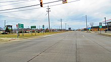
In between, it serves mostly residential areas running parallel to a pair of rail lines; the highway carries between 5,000 and 43,000 vehicles per day on average.
Once in the city of Detroit, Fort Street runs parallel to I-75 for several miles before they separate near the Ambassador Bridge.
The northern end of M-85 is at the intersection with Griswold Street in downtown Detroit, one block away from Campus Martius Park.
The current M-85 was created in 1956 after the construction of the Detroit-Toledo Freeway; the original northern end was at an intersection with US Highway 25 (US 25) in downtown.
There are many businesses directly adjacent to Fort Street in the Downriver area with residential subdivisions on either side of them.
The highway returns to a due northerly course near Memorial Park and continues along the Southgate–Wyandotte city line.
When the trunkline crosses the North Branch of the Ecorse River, M-85 enters the city of Detroit near Outer Drive.
North of the intersection with Schaefer Highway, M-85 meets an interchange with I-75 and passes under the freeway, crossing to its northwest side.
Fort Street continues through the Delray neighborhood and past Woodmere Cemetery before crossing under I-75 again; there is no interchange at this location.
[7] All of M-85 has been listed on the National Highway System,[8][9] a network of roads important to the country's economy, defense, and mobility.