Measurement while drilling
A drilling rig is used to create a borehole or well (also called a wellbore) in the earth's sub-surface, for example in order to extract natural resources such as gas or oil.
During such drilling, data is acquired from the drilling rig sensors for a range of purposes such as: decision-support to monitor and manage the smooth operation of drilling; to make detailed records (or well log) of the geologic formations penetrated by a borehole; to generate operations statistics and performance benchmarks such that improvements can be identified, and to provide well planners with accurate historical operations-performance data with which to perform statistical risk analysis for future well operations.
However, the main impetus to development was a decision by the Norwegian Petroleum Directorate to mandate the taking of a directional survey in wells offshore Norway every 100 meters.
This decision created an environment where MWD technology had an economic advantage over conventional mechanical TOTCO devices, and lead to rapid developments, including LWD, to add gamma and resistivity, by the early 1980s.
[citation needed] Essentially, a MWD operator measures the trajectory of the hole as it is drilled (for example, data updates arrive and are processed every few seconds or faster).
Additional measurements can also be taken of natural gamma ray emissions from the rock; this helps broadly to determine what type of rock formation is being drilled, which in turn helps confirm the real-time location of the wellbore in relation to the presence of different types of known formations (by comparison with existing seismic data).
[citation needed] Density and porosity, rock fluid pressures and other measurements are taken, some using radioactive sources, some using sound, some using electricity, etc.
Directional drillers rely on receiving accurate, quality tested data from the MWD operator to allow them to keep the well safely on the planned trajectory.
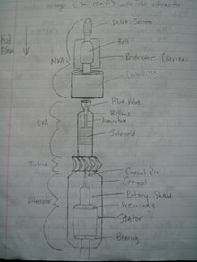
These sensors, as well as any additional sensors to measure rock formation density, porosity, pressure or other data, are connected, physically and digitally, to a logic unit which converts the information into binary digits which are then transmitted to surface using "mud pulse telemetry" (MPT, a binary coding transmission system used with fluids, such as, combinatorial, Manchester encoding, split-phase, among others).
[citation needed] This is done by using a downhole "pulser" unit which varies the drilling fluid (mud) pressure inside the drillstring according to the chosen MPT: these pressure fluctuations are decoded and displayed on the surface system computers as wave-forms; voltage outputs from the sensors (raw data); specific measurements of gravity or directions from magnetic north, or in other forms, such as sound waves, nuclear wave-forms, etc.
[citation needed] MWD tools are generally capable of taking directional surveys in real time.
The tool uses accelerometers and magnetometers to measure the inclination and azimuth of the wellbore at that location, and they then transmit that information to the surface.
[citation needed] LWD tools are able to measure a suite of geological characteristics including density, porosity, resistivity, acoustic-caliper, inclination at the drill bit (NBI), magnetic resonance and formation pressure.
Downhole, a valve is operated to restrict the flow of the drilling fluid (mud) according to the digital information to be transmitted.
[citation needed] These tools incorporate an electrical insulator in the drillstring, but due to the challenges of receiving data through a good conductor (Salt Water) this approach is largely confined to onshore areas without shallow saline aquifers.
[citation needed] The EM tool generates voltage differences between the drillstring sections in the pattern of very low frequency (2–12 Hz) waves.
However, it generally falls short when drilling exceptionally deep wells, and the signal can lose strength rapidly in certain types of formations, becoming undetectable at only a few thousand feet of depth.
The IntelliServ[13] wired pipe network, offering data rates upwards of 1 megabit per second, became commercial in 2006.
Representatives from BP America, StatoilHydro, Baker Hughes INTEQ, and Schlumberger presented three success stories using this system, both onshore and offshore, at the March 2008 SPE/IADC Drilling Conference in Orlando, Florida.
MWD tools may be semi-permanently mounted in a drill collar (only removable at servicing facilities), or they may be self-contained and wireline retrievable.
This would require the drillstring to be pulled out of the hole to replace the failed components, thus making the wireline operation a waste of time.